 |
 |
 |
 |
 |
|
|
|
|
|
![[image of flower]](../../ima/flowXS_04.gif)
Black River Canal |
|
As the Erie Canal neared completion and as its benefits began to be fully appreciated, there arose a cry from all parts of the state for canals with their attendant blessings. The people of the Black River region were not remiss in seeking for their localities a share of the prosperity that was so apparent along the route of the Erie. Consequently, the Legislature of 1825 received several petitions from the inhabitants of Herkimer, Oneida, Lewis and Jefferson counties, who desired public aid in making a canal to connect the Black River with the Erie Canal. These petitions were prompted, no doubt, in part by the attitude of Governor Clinton, who, in his annual message of that year, suggested such a connection. The friends of the measure argued that the country was one of the most fertile parts of the state; that it had a very considerable population, and was capable of sustaining four or five times as many; that it abounded in valuable timber, besides a great amount of iron ore of good quality. They raised the point that the manufacture of iron, if a canal were built, would steadily increase, and that the tonnage of this article, of agricultural products, of lumber and of manufactured goods of various kinds would give an amount of tolls amply sufficient to pay a fair dividend upon the outlay of money invested. The area of country that would be tributary to the proposed canal and feeder was estimated at 2,000 square miles, and its population, by the census of 1825, at 28,554. Whitford The petitioners also mentioned several other advantages to be obtained by opening a canal: one was the increase in value of public lands. The Moose River tract alone contained 219,000 acres, to which there was no easy access. Consequently, it was unsalable and not increasing in value, but it was believed that a canal would bring it into market at an early day and at an advanced price. Another benefit was the permanent and ample supply of water which this canal would afford to the Rome level of the Erie Canal. Time has proved that this was the greatest benefit of all of those advanced, for the very existence of the Erie has largely depended on this supply. As transportation on the Erie increased and the nearer streams diminished, this source of supply became of more consequence every year. The petitioners also believed that such a canal would assist in securing the northern frontier, which could not be effectually done without a naval force on Lake Ontario, for which Sackett’s Harbor was the most suitable station. This argument was sustained by the fact that this post was so important during the War of 1812, that the amount paid for transportation of military stores through the Black River country was believed to have exceeded $2,000,000. Application was made for the exact information on this subject to the Secretary of War, but it was not able to furnish the information to the petitioners. Whitford The Legislature had also received petitions from several other parts of the state for the establishment of canal routes, and in answer to them, passed an act providing for the surveys of certain routes, which included one from the Erie Canal in Herkimer County to the upper waters of Black River, then to the most eligible route to the St. Lawrence River, at or near Ogdensburg, and another from the Erie Canal near the village of Rome in Oneida County by the way of the Black River to Ogdensburg. Whitford The canal commissioners, whose duty it was to authorize surveys and estimates to be made under the provisions of this act, employed for making these surveys, James Geddes, an engineer who had proved his ability during the building of the Erie. Mr. Geddes examined three routes, although only two were ordered, but in directing the survey of the route other than the one to Herkimer, the Legislators who passed the law differed as to which way was meant, by Camden or by Boonville. The report showed that from the Erie Canal opposite Herkimer to the summit in Remsen there was a rise of 841 feet and from there to Lake Ontario the fall was 985 feet, to which an additional fall of five feet from Gravelly Point to Ogdensburg made the whole lockage on this line 1831 feet. As no calculation was made on more than one canal, the engineer submitted a more detailed account of the routes by Camden and by Boonville. Whitford Of the route by Boonville, he reported that it had 3 advantages over the one to Herkimer: (1) the distance of canal would be 17 miles less, (2) the lockage 180 feet less, and (3) a large supply of water for the east end of the long level of the Erie Canal could be taken from the Black River at a point where it was at all seasons a copious stream. The distance from Rome to the natural navigation below the High falls on the Black River, the engineer thought, would not exceed 35 miles, in which distance there would be 700 feet rise and 422 feet fall to the foot of the falls, making together 1122 feet of lockage, which would require 140 8-locks, just four locks to the mile. On this part of the route, some deep cutting would be required, but after reaching the falls, a fine piece of natural navigation along the Black River would be afforded to Carthage. This stream, which measured 40 miles between the falls and Carthage, following the meanderings of the river, was then used chiefly by the forge owners at Carthage. Their wares were taken up the river, the return freight being ore, which was in many places loaded into the boat from the shore with wheelbarrows. The line of survey continued to Indian River, passing many ridges and valleys, yet requiring no deep cutting or heavy embankment, nor was the course very serpentine; the fall from Carthage to the river was estimated at 234 feet. It was proposed to carry the canal on an aqueduct 33 feet above the river surface, afterwards passing through the village of Gouvernuer, then into the valley of Black-ash-flat Creek, down which there was no obstruction to the Oswegatchie River, where the canal would enter at the head of a piece of river navigation which reached to the natural canal at Cooper’s Mills, from which there was a fall of 68 feet to Ogdensburg. The whole distance of this route, from Rome to Ogdensburg, including the 40 miles of Black River, was 146 miles; deducting the course of the river, there remained 106 miles of canal to be made, to this was to be added 8 miles of feeder from a branch of the Black River to Boonville, where the summit level would be located. This made a total of 114 miles with a lockage of 1587 feet, making 198 8-foot locks. The estimate for the cost was $931,014, which embraced the following items: 114 miles of canal, at $5,000 per mile, $570,000; 1587 feet of lockage, at $150 per foot, $238,050; aqueducts, $20,000; deep cutting at several points, $30,000; dam, $4,000; superintendence and engineering, $68,964. Whitford The route by way of Camden had much less lockage than the Boonville line. Beginning at the Fort Bull aqueduct, west of Rome, it followed the Fish Creek valley for a distance and then passing through a slight cut reached the valley of the Salmon River, the whole rise from the Erie Canal being 224 feet, and the fall to Salmon River, 100 feet, then northward, traversing the face of a country of remarkable regularity, the canal would pass over the Black River on an aqueduct into West Creek valley and on to Indian River valley, down which it would be conducted to Black Lake and then to Ogdensburg. The distance by this route was about 150 miles. Adding three of feeder and deducting 24 miles of navigation in Black Lake, there would be 129 miles of canal to be made, with a total lockage of 635 feet. The estimated cost was $655,630, consisting of 129 miles of canal at $5,000 per mile, $645,000; 635 of lockage, at $150 per foot, $95,250; aqueducts and culverts, $46,000; dam, $6,000; superintendence and engineering, $63,000. As timber abounded in large quantity on the two routes, estimates were given for wooden locks. Whitford The canal committee of the Assembly, which had charge of the reports of the surveys that had been made , concluded that these various surveys and examinations, among which were included those of the Black River routes, had not been so close and critical as the importance of the subject seemed to require, and in order to obtain a more particular examination and estimates, a bill was introduced for a resurvey, but without further progress; a petition from the inhabitants of Lewis County desiring a canal from Rome to Ogdensburg brought no action. Whitford The question of constructing a canal at the expense of the State between these points again came up before the Legislature of 1827, when many petitions were sent by the people of the counties previously mentioned, appealing for the canal, several petitioners favoring the Boonville route while others advocated the one by Camden. As it was not considered advisable at that time to begin the construction of either route until a more prosperous financial era should arrive, the matter was dropped. In the following year, petitions from citizens residing in Lewis, Oneida, Jefferson and St. Lawrence Counties were presented to the Legislature. These were different from those filed in previous years, this time a request being made for an act of incorporation to authorize certain individuals to construct a canal from Rome through Boonville to High Falls on the Black River, and to improve and use this river for navigation from the falls to Carthage. The committee's report before the Senate said that they could not "refrain from noticing one very important consideration in favor of the petitioners which if their views are right, presents strong claims to the legislature in favor of their application. . . . "This [Black] river passes through a rich and fertile country, abounding in valuable timber and inexhaustible beds of bog and mountain ore, and in every respect well calculated to sustain a dense and flourishing population. Connect this river with the Erie Canal, and it would be equal to an artificial canal of 100 miles, costing $1,000,000, because the speed on it would be nearly double, and cost nothing except the one dam, to keep it in repair. "If the above calculation be correct, it will be obvious, that by constructing 35 miles of canal, the distance from Rome to High Falls, it will give the company a navigation equal to 135 miles of ordinary canal navigation, worth $1,400,000 for an expenditure less than $400,000. "But suppose the navigation of the Black river to be only equal to 40 miles ordinary canal navigation, yet it would be worth to that company, computing it at the same rate of the other 35 miles, $457,143; giving them 75 miles navigation, worth $857,143 for the expenditure of less than $400,000." Whitford It was thought by the committee that this would be a sufficient inducement for capitalists to invest their money in the stock of the company, and although canal charters had hitherto been unsuccessful, the application was favorably reported as it was an undertaking for which individual enterprise and capital were sought for the use of beneficial objects of public improvement without injury to the State or individuals, and because a canal such as was contemplated would add a "grand artery to the Erie canal, by which the superabundance of the north would be poured into the lap of our own commercial emporium." The report was accompanied by the introduction of a bill incorporating the Black River Canal Company with a capitalization of $400,000, divided into shares of $100 each. When the bill was introduced, one section authorized the Comptroller, after being satisfied that 1/3 of the capital stock of the corporation had been actually paid in and expended toward the construction of the canal, to subscribe to the capital stock in behalf of the State, but there was determined opposition to this, and the section was eliminated. The bill as passed authorized the company to make, construct and forever maintain a canal of suitable width and dimensions to be determined by the president and directors of the company over the route stated in the application of the petitioners, the time for the completion of the work being limited to three years. Whitford The company was granted the power to acquire the land, real estate and water requisite for the canal, and certain provisions were made for the manner in which all questions were to be adjusted between the company and the owners of lands or property taken or damaged by reason of injury to waterpower or inundation of lands caused by the erection of dams. The directors named in the bill, eight in number, or any three of them, were authorized as commissioners to open books for the purpose of receiving subscriptions to the capital stock. After the act of incorporation had been passed, the commissioners of the company caused the route to be examined and an accurate estimate of the cost of the work to be made. For this, they secured the services of Alfred Cruger. The operations in the field were so conducted that a general plan of the canal could be formed without going into a minute and particular location of the works connected with it, which, it was supposed, could more properly be performed when the execution of the work was determined. The examinations were as full and perfect as the object required and as the time and money allotted would permit. Whitford The main canal was divided into two sections, the southern embracing that portion from the southern terminus of the summit level at Boonville to the Erie Canal, while the northern included the summit level, and the remaining distance to High Falls, a feeder forming a section by itself. The southern section followed very closely the course of Lansing Kill to its junction with the Mohawk, then running nearly parallel to the river till the village of Western was reached, where the river made a great deflection to the west, but was again intersected by the canal at a short distance above Barnard’s Mills, then the canal followed the west bank of the Mohawk through Rome, to the Erie Canal. The northern section began at the summit level and continued to Sugar River, which was to be crossed, the plans calling for a dam across that stream, and thence to High Falls. Whitford The length of canal that would be needed was given as 33 miles and 78 chains with a navigable feeder of 11 miles and 8 chains and a river navigation of 40 miles. The whole lockage was reported to be 1,090 feet. Of this, Mr. Cruger proposed to overcome 1,015 feet by inclined planes; the remainder, 75 feet, by locks. The dimensions of the canal were 25 feet width on the bottom, 4 feet depth of water and 32 feet width of water surface. The locks were to be 7½ in width, and 75 feet in length. These dimensions were sufficient for the passage of boats of 20 to 23 tons burden, which was as large a size as could conveniently be used on the inclined planes. It was believed by many engaged in transportation at that time that boats of this size were more advantageous for navigating canals than those of larger size and would eventually supersede the larger boats. The cost of construction on Mr. Cruger’s plan was estimated at $437,738.25, which was made up of $336,642.82 for the main canal, $40,497.15 for a feeder from the Black River, it being proposed to make it navigable and of the same dimensions as the canal, $4,168 for the improvement of the river by aid of wing dams, and $56,430.28 for incidentals and engineering. Whitford Mr. Cruger substituted inclined planes for ordinary locks because he considered that under certain conditions they were more advantageous in overcoming great elevations. He had been employed on the Morris Canal in New Jersey for two years where he had seen the construction and operation of similar planes on that waterway, and he had the fullest confidence in them as a certain, cheap and expeditious mode of performing the task. The Legislature of New Jersey in 1829 had appointed a joint committee to examine the Morris Canal and inclined planes. In their report, they said that nothing was more interesting and satisfactory than the operation of the inclined plane at Booneton by which an elevation of 80 feet in height was surmounted by a plane of 800 feet in length. The boat in which the committee passed over the plane was 60 feet in length and 8½ in width. It had in her 18 tons of stone and 100 passengers and was carried over in 14 minutes, while at the same time an empty car descended. Had the descending car contained a loaded boat, the descent would, no doubt, have been accomplished in a shorter time. The committee did not entertain the smallest doubt of the practicability of inclined planes thus applied, and of their superiority over locks in overcoming great elevations, as respects economy in time and a saving in water. Whitford Knowing as nearly as possible the cost of the canal by the survey of Mr. Cruger, the commissioners of the company opened books for subscription to the stock, and used all the means in their power to carry the law into operation. This, however, they were unable to accomplish, the reason assigned for the failure being that individuals were unwilling to engage in a work, the whole cost of which they were to pay, while they were to receive only a part of the advantages to be derived from it. The persons interested in the work were willing to relinquish their charter, provided the Legislature would authorize the construction of the work at the State’s expense, and they so stated in a petition to the Legislature in 1829. The memorial was accompanied by all the information received by the company from Mr. Cruger, together with the opinions of Benjamin Wright, well known as an able and experienced engineer, who, at the request of the company, had examined the plans and estimate of Mr. Cruger. Mr. Wright had been for 30 years intimately acquainted with every step of the ground traversed by Mr. Cruger, and was in a position to decide as to the merits of the route. He expressed his perfect confidence in the amount estimated as being sufficient for the work. He endorsed the plan and recommended the adoption of inclined planes. The petitioners of that section of country felt that they were justified in calling upon the Legislature to share in its liberalities and that they had a right to ask to be placed upon an equality with other portions of the state, in having easy access to market. They argued that the superiority of inclined planes over locks was a cogent reason for constructing the canal, not only on account of the advantages to be derived, but for the purpose of introducing into this state a method of canaling which could be applicable to other parts of the state, where it was desirable to construct canals, but where the great elevations to be overcome presented almost insuperable objections. Whitford The members of the Assembly committee examined this subject, but were not prepared to recommend to the Legislature the immediate commencement of work, as they did not believe that as yet there had been obtained sufficient information on the subject of inclined planes as a substitute for locks to warrant their adoption without further examination. Also, the canal as surveyed by Mr. Cruger was considerably smaller than the Erie, and the propriety of adopting a canal of these dimensions was doubted. They submitted these questions to the canal commissioners, the people seeking the improvement being content with this course, and the following resolutions were, therefore, sanctioned by both Houses: Whitford "Resolved, . . . That the canal commissioners cause a route of a canal from Rome to the high falls of the Black River, to be surveyed, and estimates of the cost of constructing the same to be made; and also for improving the navigation of the river to Carthage, if they shall be of opinion that the dimensions of the canal as proposed by Mr. Cruger, will not answer, or that the surveys made by him are insufficient for them to report upon. "Resolved, That the canal commissioners cause an examination to be made as to the comparative advantages of inclined planes and locks in overcoming great elevations, the difference of time passing from one level to another, and of expense of constructing and maintaining them. "Resolved, That the canal commissioners report on the above to the next legislature; also their opinion as to the propriety of adopting inclined planes on the proposed canal; also the probable revenue to be derived from the work, taking into consideration the additional tolls that will be received on the Erie canal; and such other information on the subject as they may obtain and deem worthy the attention of the legislature." The commissioners did not authorize the survey, so in 1830 the resolutions appeared in an act that directed the work to be done and a report submitted to the Legislature of 1831, an appropriation for the survey being included. As a result, in the latter year the report of a survey and estimate by Holmes Hutchinson, an engineer noted generally for his accuracy on such work was submitted. Whitford The project was, according to his report, considered perfectly feasible, although there were some parts of the work that would be expensive. The items of extra expense were: (1) the great amount of lockage, in proportion to the length of the canal, (2) the narrow rocky valley, of about three miles at the Lansing Kill, (3) the rock upon the summit level south of Boonville and the steep sidehill and uneven ground through which most of the feeder must be constructed. Mr. Hutchinson reported the whole rise and fall from Rome to the Black River as 1,078 feet, and the plan he presented was to construct 10 inclined planes similar to those built in 1829 up the Morris Canal in New Jersey, by Professor D. B. Douglass, to overcome 685 feet. For the remainder of the elevation, it was proposed to build 39 wooden locks with stone breasts at the head and walls of stone upon the sides with pavements on the sides and bottom of the canal below the locks. The length of the canal, as surveyed by Mr. Hutchinson, was 36 miles, three more than the line surveyed by Mr. Cruger. To this was added about 40 miles of river navigation to Carthage, which could be obtained at a small comparative expense without any additional lockage. Whitford Mr. Hutchinson’s survey began at Rome and followed a course northerly on the west side of the Mohawk River for five miles to Barnard’s Mills. Below this point there was a bank of shelly slate rock, and the canal would have to be formed by an embankment in the bed of the river protected from the floods and ice by a pavement upon the outside of the towpath. The canal would cross the Mohawk River in the 6th mile and continue on the east side for 8 miles to the junction of Lansing Kill with the Mohawk and for the next 3 miles it would extend up the Lansing Kill valley. The upper part of the valley presented some formidable obstructions to the making of a canal as it was narrow with insufficient width for both the construction of the waterway and the passage of the stream, and the sides were mostly composed of shelly limestone and slate rock. In order to overcome the elevation here, it was proposed to locate planes at the lower, center and upper falls and then in the intermediate spaces to erect dams and locks, afterwards forming a towpath upon the sides by excavating into the rock or by raising an embankment where the width of the ravine would allow of this mode. The summit level was estimated at 4½ miles in length and would extend from a mile above the upper falls to the intersection of the canal with the feeder, two miles east of Boonville, the level necessitating deep excavations and heavy embankments. From the north end of the summit level to High Halls, about 8½ miles, the line was located in the valley and near the southwest side of the Black River, and although there was some limestone north of Sugar River and granite near High Falls, this part of the route was considered favorable, the soil being generally easy to excavate and having an even surface. It was planned to erect a dam at the largest branch of the Sugar River and cross the north branch by an aqueduct. The proposed feeder was 9 miles long and would be taken from the Black River at Smith’s Mills, where, by raising the dam, a pond would be formed from which to draw water for the supply of the canal. This pond also would enable boats to communicate with both sides of the river. A guard lock would be required near the pond to regulate the quantity of water to be admitted into the canal and to secure it against damage by floods. For the first four miles from Smith’s Mills and also on the last two miles, the feeder was intersected by a great number of ravines and ridges that would require the removal of a large quantity of earth. Both the canal and the feeder were estimated to be constructed of the following dimensions: 20 feet width on the bottom, 36 feet width at the surface, with 4 feet depth of water. The banks to be raised in all cases three feet above the waterline of the canal; the berme to be eight feet wide on the top, and the towpath 12 feet wide; and the slopes of the banks to have two feet horizontal base to one foot rise. Whitford In regard to the Black River improvement, the principal obstructions to navigation were the shoals which consisted of gravelbars and sandbars, within the first three miles below High Falls. The river was wide, and from the shifting nature of the sandbars, it was probable that the excavation of a channel through the loose sand would preserve sufficient depth of water only until the occurrence of a freshet or high water. Therefore, instead of such a plan it was proposed either to build a dam across the river below the shoals and construct a lock at one end of the dam for the passage of boats from one level to the other, or continue the canal from High Falls to connect with the river below the shoals. The engineer thought that either plan would overcome the difficulties in the navigation, but had a preference for the continuation of the canal. From these shoals to Carthage, but little work would be required and this consisted of removing logs and stones, excavating three or four places through gravelbars, and raising the dam at Carthage one foot. As estimated by Mr. Hutchinson, the total cost of the work would be $602,554, which comprised the following items: cost of canal, Rome to High Falls, $265,272; feeder, nine miles, $67,580; 30 lift locks of 10 feet each, $62,400; 10 inclined planes of 70, 75, 95, 65, 45, 40, 60, 75, 70 and 90 feet, respectively, 685 feet, at $220 per foot, $150,700; engineering, etc., $44,592; and for improving the Black River from High Falls to Carthage, $12,000. This estimate was made upon the plan of using inclined planes for the greater descents and locks for the smaller descents. Mr. Hutchinson had become an advocate of this form of construction. He had personally examined the planes on the Morris Canal and with his report rendered a detailed account of the information he had obtained in relation to the manner of their construction and the general results of the experiment. Because of the great elevation to be overcome, and because he believed that the locations on this route were well adapted for inclined planes, and that boats could be passed by them in less time and with less expense of attendance than by locks, he favored the adoption of these planes upon the proposed canal. The idea of using inclined planes was very seriously considered for a number of years before any plan was adopted and upon this canal alone of the New York System was this scheme carefully considered. Whitford Appended to Mr. Hutchinson’s report was a statement of the canal commissioners. They did not think themselves competent to recommend the adoption of structures similar to those in use on the Morris Canal until inclined planes should have been more fully tested by time and experience. As the commissioners were unable to acquire the necessary information to enable them to furnish an estimate of the probable amount of revenue which would accrue from the canal, they refrained from saying anything on the subject. This action had the effect of delaying legislative measures on the question of constructing the canal. However, the Legislature of 1831 was furnished with an estimate of revenue by residents of the Black River country. On November 22, 1830, there had been held in Lowville, Lewis County, a meeting of canal delegates from the various towns situated on the canal route, at which was passed a resolution appointing a committee of four to correspond with the canal commissioners on the subject of revenue. The committee immediately addressed a circular to the several town committees, requesting them to furnish a statement of the actual amount of tonnage in their respective towns during the preceding year. Returns from 15 towns showed an aggregate of 30,766 tons. Nothing was heard from 19 towns, but estimating these proportionately with the others, they were expected to yield a tonnage of 20,000 tons. This made a total of 50,766, from which the committee was sanguine that tolls amounting to $49,602.32 would be collected annually with prospects of increasing 10% per year for ten years. The estimates were made exclusive of the immense quantities of wood and lime which that section of the country afforded. Whitford Besides all this information that had been presented to the Legislature in 1831, forcefull arguments for improving the transportation facilities of the territory. This was a petition from Oneida, Lewis, Jefferson and St. Lawrence Counties, whose inhabitants desired what all former petitioners had clamored for – the connection of the Black River with the Erie Canal. It was urged that the country through which the proposed canal extended was fertile and capable of being very productive; that the tide of immigration at one time had set strongly in that direction; that the territory was increasing rapidly in population and wealth, with prospects of rivaling the most promising portions of the state, when the construction of the Erie Canal had destroyed these sources of its prosperity. Immigration was diverted into different channels; more distant citizens could transport their products to market with such facility as to compete with the inhabitants of the Black River section and destroy the advantage of their proximity to market, which they had formerly enjoyed, and for which they had paid in the advanced cost of their lands. In consequence, their property had depreciated in value, while they were doomed to witness other more favored parts of the state growing rapidly and increasing in prosperity, happiness and wealth by the very means that had depressed and arrested their own progress. The Black River Canal would counteract these disastrous effects, and enriching that portion of the state. Whitford However, the feasibility of the project, its cost and the probable revenue to be derived from it were still, in the estimation of many, necessary matters of inquiry. The great elevation which had to be overcome seemed to be a stumbling block of the whole project and appeared the more objectionable when compared with that of other State canals. In comparing the length of several canals and their aggregate rise and fall, it was shown that the Black River Canal, not 36 miles long, would have to overcome a greater elevation than the combined Erie, Champlain, Oswego and Cayuga and Seneca Canals with their total of 1,074 feet of lockage and 483 miles of waterway. As the Legislature did not consider it proper to proceed with the work, no immediate action was taken. Whitford Again in 1832 another petition was before the Legislature, but asking for an act to incorporate the Black River Company, which proposed to connect by railroad or canal the Black River with the Erie Canal, the act of 1828 incorporating the Black River Canal Company, having expired. The enactment soon followed incorporating the company with a capital stock not to exceed $900,000, which was to be divided into shares of $50 each. The company was authorized to construct one or all of six sections, provided that one or more of them should be completed within three years from the passage of the act, in which event a further term of ten years would be allowed the company for perfecting the whole route or any of the sections. The following were the sections: Whitford 1. A section from the Erie canal to the High falls of the Black river. 2. A section from the first through the county of Lewis and the village of Watertown to Sackett’s Harbor. 3. A section from Carthage to Sackett’s Harbor. 4. A section from either the second or third to the village of Cape Vincent. 5. A section from the village of Carthage to the navigable waters leading to the village of Ogdensburg. 6. A section for the improvement of the Black river from the High falls to Carthage and for its navigation by steamboats. The law also authorized the company to transport persons and property over the routes for a term of 50 years, but in case of failure to complete one of the sections within three years, the act was to become null and void. The usual powers were allowed for obtaining the right of way where, at the option of the company, it was necessary to locate any of the routes. Whitford Two years later, in 1834, after no attempt had been made by the company to accomplish the work embodied in the act of 1832, the attention of the Legislature was again called to the subject, the people interested being of the opinion that the work, if constructed at all, must be made and controlled by the State. The importunities of the people resulted in the Legislature passing an act directing the canal commissioners to "cause a route of a canal from the navigable waters on Black river, below the High falls, in the town of Turin in the county of Lewis, to the Erie canal, to be surveyed, in the shortest practicable direction with regard to the cost of construction and public utility; and a navigable feeder from Black river to the summit level of said canal, and estimates of the cost of constructing said canal and feeder to be made; and also for improving the navigation of Black river from the High falls to the village of Carthage, if they shall be of the opinion that the surveys and estimates heretofore made by Messrs. Cruger and Hutchinson have not been sufficiently minute and accurate to arrive at a correct estimate of the cost of constructing said canal and feeder, and improving the navigation of said river." The law provided for the resurvey of so much of the route surveyed by Mr. Cruger and Mr. Hutchinson as the commissioners should consider necessary to form a correct estimate of the cost; for a further examination to be made in relation to the inclined plane; and also for a report on the probable revenue that would be derived from the construction of the canal. Whitford On May 22, Timothy B. Jervis was appointed by the commissioners to make the examinations, surveys and estimates. He was also directed to furnish an estimate of the cost of as many planes, if any could be substituted for the ordinary lift lock, and report his opinion of the utility of inclined planes. The service was performed and the engineer’s report was submitted to the Legislature of 1835. The line upon which the survey was made commenced at nearly the same point on the Erie Canal and pursued in general the line of the former surveys. The lateral distance from the former lines was nowhere more than about a quarter of a mile. At Lansing Kill there was a material deviation in method. Former plans had provided for overcoming the rapid descent from the narrows to the kill, 170 feet, by inclined planes, and a slack water navigation by dams and locks, but Mr. Jervis proposed to overcome the elevation by 17 locks of 10 feet lift each, located at the following distances from each other: 33; 15, 24, 15, 12, 15, 12, 12, 15, 12, 9, 15, 12, 12, 9, 12 and 27 chains. As in the former surveys, it was proposed to take the feeder to the canal from the Black River at Smith’s, about 9 miles above the village of Boonville. Whitford In reference to the improvement of the Black River between High Falls and Carthage, Mr. Jervis said: "the obstructions to navigation between those points consist mostly of sand bars which occur at different places for the first 20 miles below the falls." The plan advocated to remove these obstructions was "by the excavation of the channel so as to obtain a sufficient depth of water, and by guarding the channel by constructing wing dams to concentrate the current, so that its deposits would be carried through and lodged in deep water below the bars." The expense of improving the river was estimated at $20,840. Whitford For the purpose of obtaining information in regard to the utility of planes, and the expense of their construction and maintenance, Mr. Jervis visited the Morris Canal, and in his report stated: "Experience has not, in my opinion, fully established the propriety of adopting this mode of overcoming elevations on canals, of the size of the one proposed. Although there seems to be no mechanical difficulty in the construction or operation of inclined planes, yet as the machinery is more complicated, it necessarily follows that more contingency will attend their use than that of locks. In regard to the experiment thus far, it may be observed, that those most acquainted with the planes on the Morris Canal, while they speak with decided confidence of their utility, are not satisfied with any plan now in operation. It is therefore evident they deem improvements to be essential to their complete success. Whether such improvements will materially affect the expense, can only be determined by experiment." Whitford The engineer recommended the adoption of two inclined planes, not because it was indispensably necessary, but because it would save about $30,000 and give to the public the advantage of an experiment, but in the event of the planes proving unsuccessful, it would result in a loss, according to the estimate, of $73,871.20, besides the interruption to navigation. His plans provided for two inclined planes, 10 combinations of two locks each, 15 combinations of three locks each and 74 single locks, but if the planes should not be adopted, 11 additional single locks would be necessary. The survey gave the total rise and fall at 1,083˝ feet; the length of the canal and feeder at 46 76/80 miles; the river at 40 miles; and the aggregate cost of the canal, feeder and river improvement, on the plan of adopting two planes, combined locks of stone masonry and single locks with wooden chambers, at $907,802.72. if this plan was changed so as to construct all the locks of stone, the cost would be $1,019,221.72 with the inclined planes eliminated, the combined locks made of stone, and the single locks with wooden chambers, the cost would be $940,540.20, but with all the locks made of stone, $1,068,437.20. The survey and estimates were based upon a canal of 26 feet width at bottom, 40 feet at waterline and four feet depth of water, calculated for boats of 40 tons burden; the feeder to have the same dimensions, except the bottom, which was to have a width of 20 feet. Whitford To the report of Mr. Jervis, the canal commissioners appended a statement concerning the probable revenue, comparing the Black River district with the districts dependent on the Crooked Lake and the Chemung Canals, as the latter were thought to exceed in extent and productiveness the proposed Black River Canal. The combined tolls for 1834 on both canals were $4,850.03 for 47 miles. According to these rates, the tolls for the first year of operation on the Black River canal would be $8,976.53, provided the district through which it passed should prove to be as extensive and productive as the districts held in comparison. The commissioners were unable to account for more than this amount, as they were not provided with the details of the actual business and transportation of the Black River country. In summing up the question as to whether the canal should be constructed, they were of the opinion that the last survey, as well as former ones, was insufficient and that a further survey should be made. Whitford About a month after the engineer’s report had been submitted to the Legislature, several petitions were presented to the Assembly relative to constructing the canal by the State. The petitions were accompanied by a printed pamphlet that was published at the instigation of a committee chosen at a meeting held at Collinsville, Lewis County to ascertain the probable amount of tonnage on the proposed canal. The result of the committee’s labors was embraced in the pamphlet, which showed that the canal would yield a revenue of $74,206 per annum. Believing in the accuracy of this estimate, the Assembly committee on canals and internal improvements introduced a bill for the construction of the canal, but when it came up for final passage, it was defeated by a vote of 67 to 37. Whitford In 1836, petitions sent to the Senate bore results, for in that year a law was passed authorizing the construction of the canal, section one reading thus: "The canal commissioners shall proceed, with all reasonable diligence, to construct and complete a navigable canal, from or near the foot of the High falls in the Black river, in the county of Lewis, by the most advantageous route, to the Erie canal at Rome; and also a navigable feeder from the Black river to the summit level near the village of Boonville." The width and depth of the canal and feeder were to be determined by the commissioners, as was also the method of overcoming elevations, whether by means of inclined planes or by locks constructed of wood, stone, or stone with wooden chambers or by means of both locks and inclined planes. The act specified that the feeder and canal should be so constructed as to pass as large a quantity of water to the Erie canal as could reasonably be spared from the Black river, and from the northerly portion of the Black River canal. The river from the High falls to Carthage was to be made navigable for steamboats drawing four feet of water. The law also contained a provision for supplying funds, and the commissioners of the canal fund were empowered to borrow, on the credit of the State, a sum not to exceed $800,000, or to borrow from time to time such sum or sums as should be required for the work. Section ten stated that the waterway should be known by the name of "The Black River Canal and Erie Canal Feeder." Whitford Although the Senate had before it a petition for the canal from the inhabitants of the interested counties, the real reason for authorizing its construction was the same as that which has kept it in existence ever since – the need of a greatly increased water supply for the Erie Canal, the enlargement of which had been ordered in 1835. The forests on the head waters of the Black River were looked to for a large share of the water that was necessary to supply the Rome level. That a large supply of water was wanted beyond that which was then furnished on that level was officially announced to the Legislature by the report of the canal board. Another factor that operated in favor of the canal was the fact that the State would be benefited to a considerable extent by its construction because of there being large tracts of public lands, the value of which would be enhanced by the accomplishment of the contemplated project. Whitford Since this subject was before the Legislature of 1835, the State had had one more year’s experience under the canal system, and the result was not only gratifying, but a most triumphant vindication of the wisdom of its projectors, and of the successful management on the part of those who had it in charge. The increase of business had been such that, notwithstanding a reduction in the rates of toll, the revenue continued to increase and it was anticipated that the business of the system would show a decided gain with the Black River Canal in operation. The canal and river improvement would afford a cheap and easy access to a vast timber and lumber region and New York City and in fact all the cities and villages on the route of the Erie Canal as well as the flourishing places on the Hudson River, where lumber was scarce, seemed to have a direct interest in the contemplated work. During the time that the Senate committee had the subject under consideration, the Assembly had tabled several petitions, but it concurred in the measure shortly after it was delivered to that House. Whitford In 1836, the canal commissioners detailed Portous R. Root, who had been assigned to take charge as principal engineer of the construction of the canal, to visit the Morris Canal in New Jersey in company with two other engineers, Messrs. Hutchinson and Mills, and to make a personal examination of the inclined planes. They found the planes in successful operation and exhibiting a state of improvement in that peculiar mode of transportation, but no certain information could be obtained as to their cost of construction. One of them, which overcame an elevation of 54 feet, was estimated to have cost about $17,000, being little more than $300 per foot of lift. The width of the Morris Canal was considerably less than that of the lateral canals in this state; its depth was four feet; its boats were of 8½ feet beam, and their ordinary weight, including boat and cargo, about 30 tons, being about ½ the tonnage of boats upon the New York lateral canals. This was the maximum weight of boat and cargo which was considered safe to be transported upon the planes, both in respect to the strength of the machinery, and the safety of the boat while sustaining its burden upon the plane. The freight of the Morris Canal was principally coal, a heavy compact article, well suited to the use of inclined planes, while a considerable portion of the freight of the Black River Canal would for many years consist of lumber, a cumbrous article, which was considered least suited to the planes. From their investigations, the engineers were of the opinion that inclined planes might be advantageously adopted upon independent canals of limited business, where tonnage was uniform, and mostly of heavy, compact articles, and where great elevations were to be overcome in rapid ascents, for by this means boats of small dimensions and light cargoes could be elevated and depressed with much greater rapidity and with less expense in the construction of the work than by the ordinary mode of lift-locks. From the considerations above presented, the canal commissioners came to the conclusion that inclined planes were not desirable upon the Black River Canal, so they adopted stone locks instead of planes and fixed the dimensions of the existing lateral canals 40, 26 and 4 feet, as proposed in the report of Mr. Jervis, as the size for this canal. The records show that the canal was built with dimensions of 42, 26 and 4 feet, while those of the feeder were 46, 30 and 4 feet. Whitford Preparatory to a location of the line for the canal, Mr. Root on September 7, 1836, began the survey, beginning at the line proposed for the improvement of the Erie Canal at Rome. The reports and maps of previous surveys provided the engineer much useful information and enabled him to direct his surveys more advantageously than he could otherwise have done. Only a small portion of the line was finished that year, so that a report of the entire survey was deferred until the next season. Meanwhile, the contemplated movement of diverting the waters of Black River to supply the Black River Canal and Erie Canal feeder aroused opposition from owners of the surplus water of the river at the Fish Island dam in the village of Dexter located near the mouth of the river in Jefferson County. They presented a memorial to the Legislature of 1837, stating some of the grounds of their asserted rights. They pointed out the fact that the Legislature, by act of March 8, 1811, vested the surplus water of Black River at the lower rapids in the Black River Navigation Company, and that they were the owners of that water, together with the land on both sides of the river at that point. They claimed the right to use the water for their own advantage, as independently of foreign interference, as they did their land or any other property and requested the State to pause and consider before diverting the waters, but here the matter rested. Whitford In the following year, the report of Mr. Root was submitted to the canal commissioners. He reported that the canal from Rome to the point of intersection with the river below the High Falls was 34 miles and 74 chains in length; the river from this point to Carthage was 42 miles and 40 chains, making the distance from Rome to Carthage, by the canal and river 77 miles and 34 chains; the feeder from Black River was 10 miles and 2 chains in length. The summit level was elevated above the Erie Canal at Rome 693 feet and would be overcome by 70 locks as follows: 3 combinations of 3 locks each with lifts of 10 feet; 1 combination of 4 locks with 10 feet lift; 2 single locks of 8 feet; 3 single locks of 9 feet and 52 single locks of 10 feet lift. The descent from the summit to the river where the canal was to intersect was 387½ feet and 38 locks would be necessary to overcome this elevation. Of these, there was 1 combination of 3 locks; 4 combinations of 4 locks each with lifts of 10 feet; 1 combination of 6 locks with lifts of 12 feet; 8 single locks of 10 feet; 4 single locks of 9 feet and 1 of 9½ feet. The total number of locks would be 108, combining an elevation and depression of 1,080˝ feet. Whitford The engineer stated that to obtain its necessary feeder elevation, the water in the river would have to be raised 12 feet and to do this it was proposed to construct a dam 20 feet high and 200 feet long across the river a short distance above the mill dam at Smith’s Mills (Forestport). The report suggested two methods of making the Black River navigable for steamboats drawing four feet of water, as required by the act of 1836: (1) by erecting at several points across the river dams of sufficient height to raise the water to the depth of five feet with a lock at each dam to transfer boats from one level to the other, and (2) by jetties or wing dams and parallel piers, so as to contract and govern the stream, trusting to the force of the water to keep the channel clear, when once it was made clear by this force, or by excavation, if necessary. The cost of the entire work as estimated by Mr. Root was $2,431,699.29, with the Black River improved by locks and dams, or if by the erection of jetties and parallel piers the estimate was placed at $2,421,004.77. Whitford The first work in the construction of the Black River Canal was put under contract on November 11, 1837 at $468,865.71. On May 24, 1838, there was offered at a public letting at Boonville all the work on the line extending from the mouth of Lansing Kill to Boonville, including 6 locks, the propositions for which had been declined at the previous letting; and also the work on the Black River feeder, 10 miles long with all its mechanical structures except the guard lock and dam at its head. The locks offered were numerous and many of them were located in a rough, woody country. The quarries near the line of the canal had not been worked, and although partially opened, fears were entertained by contractors that stone of suitable quality and in sufficient quantities could not be found within a reasonable distance. Proposals for many of the locks were for prices so high that it was considered most prudent in some cases to decline their acceptance and to defer the letting of a portion of the locks advertised until the quarries could be further opened in the belief that the search that would be made by those whose bids had been accepted, together with some further effort for that purpose at the expense of the State, would in a great measure dissipate the contractors' fears on that subject. Whitford The contractors for locks set themselves to opening and examining quarries and making preparations generally for the performance of their contracts. On September 5, 1838, there were let at Boonville contracts for work from Boonville nearly to High Falls, including the locks offered at the May letting, but not taken, and also including 8 locks contracted for at the November letting, in 1837, but afterwards abandoned by the contractors. At least 66 locks were offered, but only 47 of the prices were reasonable enough to be accepted, even though there was more confidence in finding adequate stone. However, propositions for forty-seven of the sixty-six locks were accepted and work began. Whitford While the work of construction progressed, the question of extending the canal in various directions was being agitated. In 1838, several petitions from inhabitants of Jefferson and St. Lawrence Counties interested the legislators in the extension of the Black River Canal from Carthage to either Sackett’s Harbor on Lake Ontario or Ogdensburg on the St. Lawrence River. It was stated that the traffic of the canal would be increased more than 200% by the continuation of this work. There was being sawed annually in Jefferson County and near where the extension was desired, 10 MMBF of lumber which would be enhanced in profitability $3.50 per thousand because of lower transportation cost. This county was one of the most productive in manufacturing and agriculture: there were numerous manufactories of cottons and woolens, forges, furnaces, nails, glass and machinery, while dairy products were large, and as a grazing and wheat growing county it was surpassed by only a few counties in the state. In addition it was argued that, by the construction of this short link in the chain of communications, more than 600 miles of canal and inland boat navigation would become connected with the canals of this state, forming a continuous navigation without the necessity of a single transshipment from the Ottawa River through the Rideau Canal and from the lead of Lake Huron through a chain of small lakes and rivers improved by Canada and called the Trent-Severn Canal, to St. Lawrence River, the Black River Canal, and finally to New York City. The petitioners insisted that from a military point of view the work appeared even more necessary for the government to maintain its position in time of war. The British Government had constructed the Rideau Canal, which gave them through the interior of Canada a safe approach to the very border of Jefferson County. The Black River Canal extended from 26 to 34 miles would enable the transportation of arms expeditiously and cheaply while enhancing the State economically by foreign trade with the interior of Canada in times of peace. Whitford The extension question was not acted upon at that session, but similar petitions were submitted to the Legislature in 1839, which provided for a survey of a canal route to continue the Black River Canal from Carthage to Lake Ontario and the St. Lawrence River and also from Carthage to Ogdensburg. The result of the survey was to be reported to the Legislature in 1840, together with the estimated cost of the extension, the probable amount of revenue to be received, and an estimate as to what extent the revenue on the Black River canal would be increased, in the event of the extension being constructed. Edward H. Brodhead, a civil engineer, was appointed to make the survey, two other engineers being assigned to assist him in the work. The surveys and estimates were made for a canal of the following dimensions: the depth of water to be 4 feet, width of bottom 26 feet, and the surface of the water 42 feet, the banks to be 3 feet above the water line, with a slope of two feet horizontal base to one foot rise, both in front and rear, the width of the towpath to be 12 feet on top, and the berme 7 feet. Several routes were surveyed, the names of the routes, the number of locks, their length, the amount of lockage, and estimates of cost being as follows: Whitford Carthage to Sackett’s Harbor – Length, 31Ľ miles; 50 locks, 480 feet lockage, total cost with stone locks, $1,444,614.28, with composite locks, $1,230,629.28, with wooden locks, $1,040,027.28. Carthage to Dexter – Length, 27ľ miles; 50 locks, 480 feet lockage, total cost with stone locks, $1,394,036.32, with composite locks, $1,180,176.02, with wooden locks, $988,943.02. Carthage to French Creek – Length, 34˝ miles; 48 locks, 480 feet lockage, total cost with stone locks, $1,327,874.67, with composite locks, $1,086,585.67, with wooden locks, $894,108.67. Carthage to Ogdensburg – via Oxbow and Oswegatchie River – Length, 77-1/8 miles; 54 locks, 527 feet lockage, total cost with stone locks, $1,681,150.41, with composite locks, $1,417,410.41, with wooden locks, $1,179,910.41. Via Gouverneur – Length, 72-3/8 miles; 64 locks, 621 feet lockage, total cost with stone locks, $2,515,199.87, with composite locks, $2,217,566.87, with wooden locks, $1,948,150.87. Via Little Bow Landing and Oswegatchie River – Length, 72-3/8 miles; 53 locks, 517 feet lockage, total cost with stone locks, $1,954,274.48, with composite locks, $1,688,433.48, with wooden locks, $1,447,230.48. The canal commissioners transmitted the report of the survey to the Legislature in 1840, but they did not give the information regarding the revenue to be derived as they were not able, at that time, adequately to estimate any amount. The introduction of a bill to build the extension followed, but upon final passage the measure was defeated by a vote of 63 to 26. Later, the Assembly passed the following resolution: "Resolved, That the Canal Commissioners report to the next Legislature, an estimate of the expenses of constructing the extension of the Black River canal, from Carthage, to some point or points on Lake Ontario or the River St. Lawrence; the probable amount of revenue to be derived from the same when in full operation, and the probable amount of increase of revenue to that part of the Black River canal already authorized to be constructed, and such other matters as shall have a bearing on the expediency of extending the Black River canal." The commissioners reported at the time designated and stated that any estimate would necessarily be conjectural; that they did not feel authorized to submit any estimate which might be taken as a basis for legislation, and referred the legislators to the report of Mr. Brodhead for the estimated cost. From the best information that the commissioners were able to obtain, an opinion was expressed that the total revenue which would accrue to the State from this extension would not, for a number of years at least, defray the cost of repairs and superintendence. In this year several more petitions were received imploring the State to proceed with the undertaking and another bill was before the Assembly, but it never came from the committee on canals. A large number of similar petitions appeared before the Legislatures of the next few years. Whitford In 1839, the work, though not all under contract, was considered as being in a successful state of progress. During the year, the work of opening quarries and procuring materials had been actively prosecuted, and it was gradually discovered that stone of a superior quality and in great abundance existed within convenient distances from all the locks on the southern extremity. In many instances, so convenient were the quarries that the stone for the lock walls were either quarried from the lock pits or dragged on stone boats from quarries within a few rods. This condition made it favorable for putting under contract the remainder of the work at prices much below those proposed at the former lettings. However, as doubts existed as to whether funds could be realized for the balance of the appropriation, the funds on hand being barely sufficient to carry forward the work then under contract to the close of the Legislature of 1840, the letting was deferred. Whitford Late in the autumn of 1839, the commissioners of the canal fund succeeded in obtaining funds for a part of the balance of the appropriation, and a portion of the remaining work was advertised to be let at Rome on December 19. The bids for the work located on the south part of the line were numerous and the prices were much lower than had been proposed at the two previous lettings. In 1840 the Legislature passed an act appropriating $250,000 toward the work and in 1841 another appropriation amounting to $300,000 was made. Up to the first of January, 1841, the portion under contract amounted to $1,680,079.73, of which work had been done and paid for to the amount of $1,197,348.65. Certain locations on the line had not yet been put under contract, but the letting was further delayed because the act directed that no work should be let during the year except such as was necessary to render available the work then in progress. Whitford In 1841, the deficiency of water on the Rome level made it necessary to render the feeder available as soon as possible. Therefore, surveys and estimates were made of that part of the work not under contract. This consisted of a dam across the Black River, a guard lock and sluice for admitting the waters and a section of the feeder connecting with these structures. The work was let on August 31, to be completed on September 15, 1842. The extraordinary and long continued dry weather of the year afforded a very favorable opportunity for testing the value of the Black River as a feeder to the Erie Canal. Mr. Frothingham, the resident engineer on the feeder, received directions to make exact measurements of the water afforded by this river. He therefore measured the stream and ascertained that there were during a period of lowest water 11,500 cubic feet per minute available, showing a result that was considered satisfactory and which set at rest all doubts as to the value of the river as a feeder. Whitford On the remainder of the canal where work was under contract, steady progress was made until 1842, when what was known as the "Stop law" was passed for the purpose of "paying the debt and preserving the credit of the State", which caused a suspension of work on all canals of the State. In 1843, the acting canal commissioner, having in charge the canal and feeder, made a report to the Senate in answer to a resolution of that body calling for an estimate of all the work necessary to complete the waterway according to the original plan of construction; also for an estimate to complete, but by substituting composite in place of stone locks for those which had not been placed under contract; and for a statement of the situation of the work that would be required in order that a full understanding of its actual condition might be had. The commissioner replied that the estimated amount required to finish the canal and feeder with composite locks was $436,740.96 and with stone locks, $639,000.01, showing a saving in favor of the former plan of $202,259.05. He also stated that the foundations of locks, the work on aqueducts, canal embankments and all unfinished work necessitated expenditures for their preservation and security. Whitford In 1844, perishable materials that had been delivered along the line of the lateral canals, having been paid for by the State and surrendered by contractors because of the Stop Law was authorized to be sold, and the revenues appled toward preserving and securing the works from decay. This provision afforded but little relief for although every reasonable attempt was made to dispose of the materials on the Black River Canal at almost any price, these efforts proved entirely unavailing for the reason that the supply of most kinds of lumber in that region was far greater than the local demand. Consequently, no sales could be made. In order to realize as far as possible some portion of the required means for protecting the work on this canal, the superintendent of repairs on the Rome section of the Erie Canal was directed not only to sell but to use for the repairs of the Erie Canal any of the perishable materials on the Black River route and to account for them at fair market prices. The materials, consisting of a considerable quantity of round and square timber and some plank, was hauled 10 miles and used to advantage on the Erie Canal, but the total sum realized from this source was only $351.84. This sum was used in protecting the works from decay, and an additional sum for the same purpose was afforded by the appropriation of $2,500 under an act of 1846. Whitford In 1846, a new State Constitution was adopted declaring that the canals should forever remain State property and provided, in section 3 of article 7, for funds to be used in completing work on the canals. The Constitution stipulated that the money should be appropriated by the Legislature from the surplus revenues of the canals. Accordingly, in 1847, an act was passed that gave the canal commissioners the right to decide whether the locks should be composite or stone, and appropriated $100,000, ½ of which was to be realized from a loan of $30,000 due from Albany and from the proceeds of a loan of $20,000 to the Lewis County bank. Whitford On June 19, notices were published that proposals would be received by the canal commissioners at Boonville until July 21 for the feeder dam across the Black River, for necessary bridges and wasteweirs, and for finishing all other work of the feeder, except on section No. 2. Bids were received and contracts let for the performance of this work, all of which was to be completed by June 15, 1848. The contracts for section No. 2, and for the guard lock located at the head of the feeder, which had been entered into previous to the suspension of work in 1842, had not been canceled, and the contractors, after waiving all claims for damages on account of the suspension, voluntarily proceeded to the completion of these works. On September 10, proposals for lock work near the summit level were also received and contracts awarded. At an adjourned session of the Legislature, a further appropriation of $50,000 was made under an act passed on December 13, and more work was contracted. During 1848, in which year $130,000 was appropriated by act, contracts were let for work from Boonville to Port Leyden. Whitford On October 18, 1848, water was first let into the feeder. Stop gates, which could be closed immediately in case of accident, previously had been constructed at several of the most exposed points. While the water was being admitted, watchmen were stationed along the banks to observe any indications of failure. The water was allowed to flow through it to the depth of about two feet, and no indications of weakness were observed in the banks, when it was drawn off to allow some docking to be completed near the head of the feeder. On December 12, the water was again let into the canal for the purpose of testing the strength of the banks with a full depth of water and to determine its capacity for supplying the requisite quantity of water for the enlarged Erie Canal. On the next day, a boat passed from Boonville to the head of the feeder and back again, but on the morning of the 14th, the water having the full depth of four feet and very little leakage being observable, a section of bank about 50 feet long was carried out to the depth of canal bottom. On June 2, 1849, the feeder was again filled, but only to a depth of two feet, the water being kept at that depth until the 20th, when it was drawn off to repair the bottom. The water was again let in on June 23 for the purpose of feeding the Erie Canal, being kept from 2 to 2½ feet deep until July 4. Then it was increased to 3 feet in depth and, except for 36 hours, remained so during the summer. This depth took nearly all the water from the river for about three months, but furnished only about 9,000 cubic feet per minute, little more than half the former estimates of the supply from the Black River. The feeder was designed to pass 16,000 cubic feet per minute with a depth of four feet of water, and although it had not been tested with this depth, the experiments were deemed sufficient to prove that the capacity of the feeder would not vary much from the original design. But now a new difficulty arose: the inability of the natural flow of the river during the summer to furnish a quantity of water that would equal the capacity of the feeder. This led to the establishment of a system of reservoirs that has grown until it is now the chief dependence of the Rome level for its supply of water. It was seen at that time that resort would have to be made to reservoirs at the numerous small lakes, lying from 10 to 20 east of the head of the feeder, not only to obtain the quantity of water necessary for the canal, but to restore to the river the amount taken away and thus to prevent extensive claims for damages to waterpower users on the river below. A survey was made of these lakes that covered an area of 1,163 acres, and received the drainage from about 3,000 acres. A temporary dam of five feet in height, built across the outlet of the former lake, was closed on November 9, and up to December 19 the water rose 1.45 feet, which was considered a fair average, no heavy rains having appeared in 40 days. Other lakes that were examined but not surveyed, appeared to afford equal facilities with these two, so that it was thought that without doubt all the water required could be obtained from this source. Whitford In 1849, contracts for the construction of 24 locks were renewed on May 8, and several other lettings occurred, additional appropriations being granted, one for $130,000 for canal work, and $10,000 for the improvement of the Black River from High Falls to Carthage. Under the latter appropriation, boats were built, suitable machinery placed upon them for removing snags, and the work was begun in that year, but nothing further was done in improving the stream until 1854. In November, 1849, 25 miles of the canal from Rome to Boonville were so far completed that water was admitted and nearly the whole length had been filled, when a breach occurred near Westernville, which rendered it necessary to dam off the water and repair the break. Whitford In the spring of 1850, this portion of the canal was brought into operation and the first boats were passed from Rome on May 10, but because of the lack of sluices around the locks and for other causes, navigation was not as good as desired. In consequence of the frequent delays to navigation during that year, it was considered necessary to build the sluices and to construct a feeder from the Mohawk River at Delta, and in the following year contracts for this work were awarded. In the previous year, the balance of the canal, three miles from Port Leyden to High Falls, was put under contract, and to carry forward the work to completion the Legislature made another appropriation of $120,000. Whitford The line from Boonville to Port Leyden was completed in time to let the water into the canal about November 1, 1850, and was brought fully into use in the spring of 1851. During this year, the Legislature passed an act directing the canal commissioners to examine and survey the lakes at the head of the Black River, and also of those on Moose and Beaver Rivers, for the purpose of creating reservoirs of sufficient capacity to supply the canal and feeder. The commissioners also were ordered to erect dams and other structures required on the streams and lakes flowing into the Black River above the canal feeder dam, and if such streams and lakes were inadequate to furnish a necessary quantity of water, other dams and structures were to be built on one or both the Moose and Beaver Rivers. The surveys were made and maps and plans adopted by the canal board for four reservoirs located near the head waters of Black River: one on the Woodhull Lakes, one on the North Branch Lake, one on the South Branch Lake, and another on a marsh a short distance below the last mentioned, their total acreage being 2,543 acres and their capacity, 1,948,308,640 cubic feet at a cost estimated at $43,635. The surveys made of the lakes on the Moose River showed their number to be eight, most of them of considerable size and located within about 18 miles between extreme points. By building a dam about 16 feet high at what was called the "Old Forge Dam," the water would be set back over five of the lakes, which embraced an area of 2,762 acres and which would be increased by the dam to 3,481 acres, thus affording a reserve of about 800,000,000 cubic feet of water. The canal at this time was still in progress of construction and work proceeded satisfactorily until 1853 when another appropriation provided $75,000, the law stating that the amount should be applied to (1) the unfinished portion of the canal between Port Leyden and High Falls (called later Lyons Falls) in order to let boats into the river at the earliest period possible, (2) the construction of a dam at the foot of slack water navigation, and (3) to be expended at such points as would be most beneficial to navigation. It was in this year that the reservoirs on the Woodhull and North Branch Lakes were adopted by the canal board and construction began. The other two were not adopted, as it was deemed advisable to make further examinations of the numerous lakes and streams connected with the Black River to ascertain if better and more available locations could be found. Whitford On January 20, 1854, the Legislature enacted a law providing for an amendment to the Constitution whereby appropriations could be made in the next four years to complete this canal. The amendment was submitted to the people and adopted on February 3 and the Legislature followed by passing an act making $49,000 the first appropriation that was authorized to spend in 1855. In 1854, the North Branch Reservoir was completed, and on November 12 the uncompleted work on three other reservoirs, and on the Black River improvement, was suspended by the canal commissioners as the amount of money provided by the Constitution and appropriated by the Legislature was insufficient to complete the work. Whitford With regard to the improvement of the Black River from Lyons falls to Carthage, insufficient attempts were made in 1849 to improve the channel. This portion was the most uncertain part of all the construction work on the canal. No action resulting in material improvement was taken prior to 1854, when two plans were proposed. One consisted of the use of locks and dams, the latter to extend across the river so as to elevate its surface to a height sufficient to furnish the requisite depth of water for steamboats drawing four feet. The other contemplated the formation of a new navigable channel by means of dredging and constructing jetty dams and piers. In 1854 the latter plan was adopted and the work placed under contract. Whitford In 1855, extensive examinations and surveys were made for the location of the two remaining reservoirs, the final conclusion being to construct one on the South Branch Lake, and the other on Chub Lake, which were put under contract. In spite of the cutoff of funds, the canal was completed on November 13 and the entire length, 35 miles, from the Black River at Lyons Falls to the Erie Canal at Rome was first used in 1856, the number of locks being 109, each 90 by 15 feet, with a lockage in elevation and depression of 1,082 feet. The total cost of construction of canal and feeder, together with expenditures for river improvement in later years, was $3,581,954. Whitford An appropriation to be applied towards unfinished work was the only direct legislative action concerning the canal in 1857. Navigation on the canal was maintained with beneficial results, and in 1862 the reservoirs were used to their utmost capacity and proved to be of great service in keeping up the supply of water for the Black River and Erie Canals. An act was passed on April 10, 1862, directing all construction contracts on the canals of the state to be closed on September 1 of that year, but the Black River Canal was not affected, as only minor work was required when it came to the date to settle all contracts. The work was prosecuted with energy until September 3, 1857, when the plan, as adopted in 1854, was abandoned by the canal board on the recommendation of the State Engineer and Surveyor, who afterwards submitted to the board new plans and estimates providing for a lock and dam at Otter Creek, 12 miles below Lyons Falls. These plans were adopted and on June 18, 1859, contracts were let for the work. The remaining portion of the improvement, from a point 300 feet north of the lower dock at Lyons Falls to Carthage, including the Carthage Dam, was advertised and let on October 10, the contractors being required to furnish five feet of water by dredging a channel sixty feet wide at the top, with sides sloping as two to one. Whitford In 1860 an act appropriated $75,619 for payments on work necessary to complete whatever remained to be finished on the improvement of the river and on other portions of the canal. In 1861, the dam and lock at Otter Creek were finished and river navigation was opened. The dam at Carthage made slack water navigation for 22½ miles between that place and Beach’s Bridge. The 10 miles between this bridge and the dam at Otter Creek were maintained, keeping the channel open by dredging. Between Otter Creek and Lyons Falls the dam at the former place gave slack water navigation. However, this plan of improvement was not entirely satisfactory, so in 1864 $24,298.51 was appropriated for the construction of a lock and dam of wood at such point between the mouth of Otter Creek and Carthage as the canal board should decide would most effectually improve the condition of the river. Surveys were made at two points to enable the selection of a proper site for the structure: one opposite Lowville, two miles below Beach’s bridge and the other at the foot of the "long reach," three miles above this bridge. The estimated cost was from $57,000 to $58,000, but as the sum appropriated was less than half the amount required, the plans were not adopted until 1865, when an additional appropriation was allowed. Whitford With the exception of ordinary repairs and renewal of lock gates, navigation on the canal and river met with no obstacles until 1869, when heavy damage was done along the line of the canal by a freshet, caused by the breaking away of the North lake reservoir on April 21, delaying the opening of navigation until the first of June. Claims for damages aggregating $700,000, were presented against the State by owners of property on the Black River, and on May 5 an act authorized the canal appraisers to hear and determine the claims. There were nearly 277 cases. In some instances, nothing was awarded, while to others were adjudged certain amounts. A number, dissatisfied with the awards, appealed to the canal board, which affirmed the decision of the appraisers and dismissed the appeals. Whitford The year 1870 witnessed the completion of some extraordinary work authorized by an 1867 act that provided for enlarging the first level at Rome to the size of the Erie. This was done to give the level a capacity for admitting large-sized boats, drawing six feet of water, and also to allow two of these boats to lie abreast for the purpose of receiving and discharging cargoes, and at the same time to permit the passage of another boat to or from the first lock. Whitford During the next few years, the question of abandoning the lateral canals was seriously agitated. They had failed to produce sufficient revenue to defray the cost of maintenance, and the public was beginning to demand release from the burden of their support. The causes which induced this condition are fully discussed under Abandonment of the Lateral Canals, so that only a few facts as they related to the Black River Canal need be noticed here. The Constitution of 1846 declared that all of the canals should forever remain the property of the State. Consequently, the first step toward the abandonment of any was an amendment of this Constitution. In the amended form, the Black River Canal was not included in the list to receive constitutional protection. The next step was the enactment of a law in 1875 requiring an examination of the lateral canals in order to ascertain "whether any of them should be sold, leased, or abandoned," or, "whether any, or any portions of any of them," were necessary to be retained as feeders. The canal commissioners, upon whom devolved the duty of investigation, reported to the Legislature of 1876 in favor of the retention of this canal on account of its availability as a feeder to the Erie. As this report was lacking in many essentials, a further examination was ordered by an act that appointed a special commission for the purpose. The report of this commission was submitted to the Legislature in 1877 and in it various reasons for retaining the canal were made. Whitford The Commissioners reported that in a tour of the line the structures were all found to be in good condition, and it was thought that for several years no extraordinary repairs would be needed; that in 1876 the tolls were $11,339.28 and the amount contributed to the Erie, $9,080.72. During the year, $35,074.13 was expended for maintenance, and it was estimated that this sum would not be exceeded annually for some years to come. Owing to the expense of maintaining the reservoirs and feeder, which constituted a vast water supply for the Erie, the commissioners considered that $17,000 of the cost of maintaining the canal was properly chargeable to the Erie route, this amount having been determined by an estimate made by a competent canal officer. The commissioners further said that the canal and feeder had proved itself to be one of the main feeders to the Erie, and chiefly for this reason they were of the opinion that the interest of the State required the maintenance of the route as a useful and necessary portion of the canal system of the State. It was planned, however, if the canal was discontinued, to feed the water from the northern forests through the Lansing Kill and Mohawk to the Erie at Rome, but the commissioners stated that the plan would result in large claims for damages. In the spring of 1875, when the Erie was opened several days in advance of the opening of navigation on the Black River Canal, an effort was made to fill the Erie by this method, without the use of the canal, but it was impossible to secure the necessary depth of water in the Rome level, and the Black River route had to be opened as a conduit for the water before the needs of the Erie could be supplied. According to the commissioners, the canal was needed as an outlet to the vast lumber districts of the Adirondack forest, which had no other means of transportation without long teaming, and it was predicted that the lumber business would increase rather than diminish. Following out their suggestions, the Legislature, in 1877, omitted this canal from the provisions of an act providing for the disposition of the other lateral canals named in the act of 1875, and in 1882, the Constitution was again amended whereby the Black River Canal was included with the canals that should be perpetually maintained by the State. Whitford In 1876 the canal was taken from the eastern division and attached to the middle division of the State canal system. Whitford Because of the large part which the reservoirs of the northern country have played in the affairs of the Black River and Erie Canals, it is purposed now to treat of them at some length, picking up the narrative where it was dropped with the completion of the North Branch reservoir in 1856, and the suspension of work on the Woodhull, South Branch and Chub lake reservoirs in the same year. Owing to grievances of riparian owners along the Black River on account of the diversion of water from that stream for the Black River Canal and feeder, an act went into effect in 1859 appropriating $49,780 for the completion of "so many of the Black river reservoirs as will, with the least expense, restore to the Black river 11,000 cubic feet of water per minute; being the quantity diverted to the Erie canal." In 1860, the Woodhull and South Branch reservoirs were completed. It had been designed to construct the Chub Lake reservoir, but work was never started after suspension in 1856. The usefulness of the reservoirs was demonstrated in 1864, when it was apparent that the Erie Canal would have suspended navigation for quite a length of time during that season had it not been for the large supply of water furnished to it at Rome through the Black River Canal. Whitford The construction of another reservoir was authorized by law, the plan being to dam Sand Lake a point about 1½ miles below Woodhull Reservoir, and in 1872 this work was completed, making the total capacity all reservoirs, 1,807,620,000 cu. ft. The water furnished by this means was drawn only in the very dry seasons, and passed down through the natural channels of Black River and Woodhull, about 20 miles each, to the pond above the dam at the head of Black River feeder, known as the Forestport Dam, which overflowed about 150 acres, from there the necessary quantity was taken into the feeder and passed to the summit level at Boonville. From this point, the canal was applied both ways, and the balance, designed for the use of the Erie Canal, was passed off by a spillway into Lansing Kill at the south end of the summit, and afterward a portion was taken into the canal at lock No. 34, from the Lansing Kill dam, then into the Mohawk River where it entered the Erie Canal by the feeder at Rome. Whitford In 1880, necessary steps were taken to increase the water storage capacity and surveys were made of the 7 Fulton lakes, and in 1881 these new reservoirs were brought into use. For the purpose of further restoring to the Black River its natural supply and to furnish the requisite quantity of water for the Black River Canal and the Rome level of the Erie, and for the owners of the mills on the river, an act was passed in 1881, authorizing the construction of reservoirs upon the Independence and Beaver Rivers. In 1883, the Legislature provided $20,000 for another reservoir, this one to be located on the Black River above Forestport Pond, and a portion of that season was consumed in surveying and preparing plans, and also in making examinations of several proposed sites for a dam on the Beaver River, the latter work having been directed by the act of 1881. Although this law provided for reservoirs on both the Independence and Beaver Rivers, it was decided to build only one dam, that on the Beaver River, and this was designed to compensate the mill owners at Watertown and Carthage for the water taken from the headwaters of the Black River and diverted to the Erie. Stillwater was selected as the best location for the reservoir, but work did not begin until the fall of 1885 and continued only until it was found that there was a defect in the law. Consequently all work stopped until July, 1886, when it was renewed and completed in 1887, the dam being 9½ feet above low water, with a spillway 150 feet long, and a capacity of 328,000,000 cubic feet. Whitford During the fall of 1884, work to the amount of $15,000 was done on the new Forestport dam, but as the appropriation made in 1883 was less than 1/3 of the $65,000 required to complete, the structure was left in an unfinished state. An ineffectual attempt was made in 1885 to pass a bill for another appropriation, but finally in 1889 the Legislature decided to furnish money for a continuation of the work. The movement in this direction was accelerated by the many complaints made in 1888 about the diversion of the waters from Black River, so essential for manufacturing purposes. In 1888, the complaints led the Senate to pass a resolution directing the State Engineer to investigate and report on the diversion problem. The investigation was made and a report presented in the following year. He determined that during the navigable season, 16,000 cubic feet of water per minute were taken from Black River into the feeder at Forestport, 11,000 of which were diverted and flowed south to the Erie Canal at Rome and the remaining 5,000 went north from Boonville and were restored to the Black River at Lyons Falls. The State Engineer made an urgent request for the completion of the new Forestport reservoir and money was appropriated for the object. The work again progressed until 1891, when it ceased on account of the funds becoming exhausted. Owing to a severe drought in this year, the Legislature was again asked in 1892, and the sum of $35,000 was authorized to be expended toward the completion of this important structure. Whitford The Legislature of 1892 also made provision for raising the dam across the Beaver River at Stillwater an additional five feet (this had also been urged by the State Engineer in 1889), as the capacity of the reservoir had been insufficient to make a full restoration of the waters diverted for State use. The work was put under contract on September 6. Whitford The contract for the completion of the Forestport dam was let in July, 1892, the work being completed in December, 1893. When the gates in the dam were closed, the water set back did considerable damage to the railroad embankment of the Mohawk and Malone Branch of the New York Central Railroad. In 1891, the Legislature provided for clearing the flow ground of the reservoir, the work being performed in the fall of 1892, and on this flow ground was located the damaged railroad embankment. In April, 1894, the embankment was washed away and the company filed claims for damages with the Court of Claims, but was awarded nothing. An appeal was then taken to the Appellate Division of the Supreme Court where the decision was reversed and a new trial granted. The State appealed to the Court of Appeals, but the case was dismissed, and in April, 1901, the claim again came on for trial before the Court of Claims, which rendered its decision in May, 1902. This decision said that the railroad company was entitled to a judgment against the State for $113,927.35 unless consent were given to the company to restore and perpetually maintain its roadbed by extending a riprap-protected embankment upon State lands at a slope sufficiently flattened to withstand the action of the water. If this consent were given, the company was entitled to damages and costs to the sum of $61,207.99. In accord with the court decision, the Legislature of 1904 authorized the Secretary of State to consent that the railroad company should reconstruct its embankment as specified in the decision. Whitford An act passed in 1896 authorized the Governor to appoint three citizens of Jefferson County and one from Lewis County, who were interested in owing and using waterpower on the Black, Beaver or Moose Rivers, to be commissioners of waterpower on the Black River, serving without compensation. The commissioners were empowered to appoint gatekeepers for the State dams on Beaver and Moose Rivers and to make rules for the management of these gates, and were also given authority to regulate the discharge of water through the gates at such times and in such quantity as they should consider proper, but not in such manner that would injuriously interfere with canal navigation or the navigation of that portion of the Black River used for canal purposes. Whitford In 1898, Mr. David E. Whitford, who was selected for the work on account of his almost continuous service on the State engineering force for more than 45 years, made a most exhaustive study of this subject of the northern reservoirs and transmitted an interesting report to the State Engineer on the water supply of the Adirondack forest. In part, Mr. Whitford said: "These reservoirs in the aggregate furnish an amount of water ample for ordinary years when the dry weather period does not demand the drawing from them the required 16,000 cubic feet of water per minute for more than three months, or say 100 consecutive days; but for extremely dry seasons, such, for instance, as were experienced in the years of 1849, 1867, 1871, 1879 and 1881, they fall far short of furnishing the required amount. "A careful perusal of the records since the Forestport feeder was brought into use in 1849, affords convincing proof of the fact that whenever a long, dry season has occurred, the canals, as well as the mill powers on the Black river, have suffered for the want of water. "It is true that a part of this shortage can be accounted for from the fact that the lumbermen have sometimes surreptitiously used the impounded water to float their logs. "But a little figuring will show . . . that the combined storage capacity of all the reservoirs that have at any one time furnished water to the Forestport feeder, would be unequal to the demand when called upon to furnish the required 16,000 cubic feet of water per minute for a longer time than 100 days in succession. "The reservoirs in present use, and which have been in use since and including the year of 1894, have a storage capacity greater by nearly 200,000,000 cubic feet than those that were in use any year previous to that date. "Still . . . these reservoirs in delivering to the Forestport feeder the 16,000 cubic feet of water per minute, would be exhausted in less than 100 days, unless they were replenished during that time by an amount that exceeded the natural loss by evaporation and filtration." 9 With Mr. Whitford’s report there were given tables showing the reservoirs in use in 1898 for the Erie and Black River Canals, and also those for the Black River improvement and waterpower on this river. In the former table there were North lake, Woodhull, South lake, Sand lake, Canachagala lake, Twin lakes, Forestport reservoir, and Forestport pond with a total capacity of 2,274,006,240 cubic feet. In the latter table included the Fulton Chain (first to seventh lakes), and Beaver River, having a total capacity of 1,650,000,000 cubic feet. Mr. Whitford said further: "The reports and records show that there have been at least five years during the last half century, or an average of one year in ten, when the dry weather portion of the year lasted about five months, and there have been other years when the drouth continued longer than 100 days. For all such years it became necessary to resort to extreme measures at considerable expense to procure the additional amount of water needed to maintain navigation through the extreme and extended dry seasons. "To provide for these protracted dry seasons of five months, or say 150 days’ duration, would require reservoirs capable of storing 3,500,000,000 cubic feet of water. "This amount, located where it would flow readily into the feeder at Forestport, would, if properly managed, not only furnish to the canals the required 16,000 cubic feet per minute for 150 days, but would give to Black river, in addition to its natural flow below Lyons Falls, the 5,000 cubic feet of water per minute that supplies and flows through the canal north from Boonville. "The water powers below Lyons Falls are receiving, in addition to the natural flow of the river, the benefit of this 5,000 cubic feet of water per minute from the present reservoirs, so long as the 16,000 cubic feet per minute taken into the feeder is being supplied wholly from the reservoirs. And as these reservoirs are capable of furnishing and do furnish, when rightly managed, that amount per minute for nearly 100 consecutive days, the riparian owners along Black river have no reason to complain. On the contrary, when the dry season is not prolonged beyond three months they have good reason for congratulating themselves and are to be congratulated, for during that period they receive, in addition to the natural flow of the river, not only the 5,000 cubic feet per minute that flows through the canal north from Boonville, but an additional 11,000 cubic feet of impounded water per minute from the reservoirs on Moose and Beaver rivers. "But when the dry weather continues longer than 100 days and the canals are being supplied from the natural flow of the river, the mills from Forestport to Lyons Falls are being deprived of 16,000 cubic feet of water per minute, and those below the falls of 11,000, if the Black river at Forestport affords the 16,000 cubit feet per minute. "It will be remembered, however, that in 1849, before any reservoirs were built, the low water flow of Black river at Forestport was only 9,000 cubic feet per minute. This fact showed conclusively that the natural flow of said river could not be relied upon during extremely dry seasons to furnish the 16,000 cubic feet per minute, and led up to the building of reservoirs to supply the deficiency. "But eight years went by before the first reservoir was completed and brought into use. "During these years the mills on Black river were short of water so much of the time and their owners presented so many bills and filed so many claims for damages, that it became apparent something must be done to restore to the river an equivalent for the water that was being diverted. "To make the restitution, however, it was quite essential to first know, approximately at least, what amount was being diverted, and the preliminary work of gauging and measuring resulted in the decision that, of the 16,000 cubic feet per minute taken into the feeder at Forestport, 5,000 cubic feet fed the Black River canal north from Boonville and was restored to the Black river at Lyons Falls, and that the remaining 11,000 went to the Erie canal at Rome. "This was the basis for act chapter 326, Laws of 1859, which made an appropriation and directed ‘the completion of so many of the Black river reservoirs as will, with the least expense, restore to the Black river the 11,000 cubic feet of water per minute, being the quantity diverted to the Erie canal.’ "If this law had been construed to mean that the reservoirs must be capable of returning to Black river the same amount per minute, during the entire number of minutes for every day each year, that was being taken from said river into the feeder at Forestport, or, in other words, if it meant that the State must impound enough water for its own use each year, so that none of the natural flow of the river would, in effect, be diverted from its natural course, it would have required reservoirs aggregating a storage capacity of more than 5,000,000,000 cubic feet, for there have been, during the past fifty years, an average of 219 days of navigation per year, and the number of minutes in 219 days, multiplied by 16,000, exceeds 5,000,000,000 as above stated. "The amount diverted to the Erie canal during that time, however, would be a little less than 3,500,000,000 cubic feet. But if these 3,500,000,000 cubic feet limited the capacity of the reservoirs, they would, under the existing conditions of supply and demand, be exhausted in about 150 days, and for the remaining portion of the season of navigation the supply would have to be taken from the natural flow of the river. "The most natural and reasonable interpretation of the law is to consider it to mean that the amount to be restored to Black river is the quantity diverted to the canals during the dry season of the year when its diversion would prove detrimental to the water powers along said river. "The State officials in charge of the canals at the time this law was passed did so construe it, and assumed the dry weather period to be 115 days per year. "Doubtless these 115 days would be a fair average, and possibly more than the real average dry weather days per year for the past fifty years. "And if there had been reservoirs from 1849 to the present time of sufficient capacity to furnish the amount of water taken into the Forestport feeder that number of days each year, and its use had been so managed as to permit the natural flow of Black river or its equivalent, to pursue its course past Forestport for 115 days during the driest portion of each year, it would, without doubt, have amounted in the aggregate to as much more than the quantity diverted to the canals during the dry seasons when the diversion seriously affected the water powers on said river. "But an average amount per year, for a term of years, does not serve the State, the boatmen and the mills the best possible way, for whenever the drouth continues beyond the term for which the reservoirs provide, not only do the water wheels along the Black river stop turning, but loaded boats frequently come to a standstill for the want of sufficient water to float them. "This results in a loss to the boatmen, the State, and, for the time being at least, to the owners of the water powers along the river, the amount of the losses depending materially upon the length of time the dry weather continues after the reservoirs are exhausted. "The losses fall the most heavily upon the boatmen for the reason that they are less able to bear them. "The greatest loss, however, in the end, comes upon the State, and is borne by the people, the taxpayers, in paying to claimants their losses while their mills are idle. "The remedy for this would be to impound an amount of water that would furnish the canals the required 16,000 cubic feet of water per minute for the longest dry season of the year. "If enough reservoirs in number and capacity to do this had been constructed and brought into use at the time the feeder was completed, the cost of their construction and for their maintenance would have been very much less, it is believed, than the amount that has been expended in settling the claims for diversion of water. "The Adirondack region furnishes a bountiful supply of water. "Great quantities run to waste when the streams are swollen and converted into torrents by the copious rains and melting of the deep snows so prevalent there. "The storing and holding in reserve of this surplus water that goes to waste would not only furnish an amount which, in addition to the natural flow of the streams, would afford a constant supply sufficient for all present needs at least, but the flood-waters held in restraint would reduce the freshet volumes to such an extent as to lessen greatly the liability of damages from them. "Whenever the additional water is impounded to supply the deficiency for the longest dry seasons, it should be stored where it will flow readily to the pond at the head of the Forestport feeder and as close to said pond as it is possible to find locations for reservoirs, so that the water can reach the feeder and canals at short notice. And if near the feeder, they would be less liable to be tampered with by outside parties. "In constructing new reservoirs, or adding to or improving those now in use, iron and stone should be used, if possible and practicable, instead of perishable material. "The total storage capacity of the ten North Woods reservoirs now in use is nearly 4,000,000,000 cubic feet. "This amount used at the rate of 16,000 cubic feet per minute would hold out for 170 days if, during that time, the rainfall in that vicinity was sufficient to make up for the natural losses by evaporation and filtration. "Therefore, if all of these reservoirs were where the water from them could flow to the feeder, the supply would be abundant for the longest dry season. Or if the water from the summit at Boonville went but one way, so that only the 11,000 cubic feet of water per minute diverted to the Erie canal was from Black river into the feeder at Forestport, then the reservoirs and the pond that now send their waters to the feeder and the canal would last nearly to the end of the longest recorded dry season. "But as one of the main objects for which the Black River canal was constructed was to provide a way for the boats to pass in the Erie canal and the navigable portion of the Black river, it was necessary to have enough water to supply the Black River canal both ways from the summit level, besides the amount sent to the Erie canal from the south end of the summit, through Lansing Kill, the Mohawk river and the feeder at Rome. "And the necessity for furnishing the additional water to supply the canal north of Boonville was why the Forestport feeder was made larger than the Black River canal. . . . "There have been no extremely dry seasons since the completion and subsequent raising of the dams on Moose and Beaver rivers to demonstrate, in a practical way, whether the waters from the present reservoirs, together with the natural flow of the streams, will be sufficient to maintain navigation on the Black river improvement, through a protracted dry season. "But if it should be found that more water is needed for said river improvement, places should be selected where the impounding of it and the frequent and extreme changes between its high and low stages would not convert into desolate wastes those beautiful summer resorts, so eagerly sought and highly prized by the multitude of seekers for health, pleasure and recreation." 10 An act passed in 1898, provided $7,000 for a tree dam on the Red Horse chain of lakes, tributaries to the Beaver River, but upon examination this was found impractical. The amount was reappropriated by an act in 1900 providing $43,000 additional "to construct a masonry dam on the Beaver river as near as practicable to the existing state dam on said river of a height to maintain the pond at the existing water line." The structure was completed in 1903. The old dam at Forestport was also replaced by one of concrete in 1903, the money for the construction being allowed by an appropriation of $45,000 under an act in the previous year. Whitford Many of the locks were becoming so dilapidated in the Black River Canal that in 1887 there was started the work of rebuilding the worst of them, the Legislature making appropriations year by year. This work of rebuilding continued till 1900. The chief trouble was the pressing in of the side walls, so contracting the chambers of the locks that in order to continue the passage of boats through them, the masonry had been cut away to such an extent that in some cases entire face stones had been removed. The locks were rebuilt of the same dimensions as the original structures. Whitford On July 23, 1897, there occurred a break in the towpath of the feeder near Forestport, which was the most costly and disastrous breach that had happened in many years. The break occurred a short distance below the head of the feeder at a place where the channel is carried along the side of the very steep river bank about 70 feet above the river, and as the soil was mostly sand with thin layers of clay, the water tore an enormous hole in the bottom and towpath bank of the feeder, 400 feet long and 50 feet deep. It required a large force working night and day for 30 days to repair the damage, and during this time all navigation on the Black River Canal was suspended and this source of water supply to the Erie entirely shut off. The expense of repairs was $62,781.78. On Mayon May 23, 1898, another serious break occurred near the same place and similar in all its features to that of the previous year. Again, navigation was suspended on the canal, this time for 21 days, and the Erie was deprived of its supply from the reservoirs. It cost $50,764.47 to repair this break. By this time, the canal officials were becoming suspicious that both of the breaks had not been accidental, but were caused by the maliciousness of persons who might be benefited by having large sums spent in the locality. During the summer of 1899, information was received which confirmed the officials in their belief, and accordingly an investigation was begun and while it was in progress, a third break occurred on September 18, at the same place and under very suspicious circumstances. This time the breach was discovered early, and by great efforts, those in immediate charge were able to prevent much of the bank from being carried out. However, the necessary repairs required a large force day and night for 17 days and cost $17,089.72, making a total of $130,635.97 in the three years. By this time, the Superintendent of Public Works had become firmly determined to bring the perpetrators of these acts to justice, and he pursued his investigations with renewed energy. After obtaining many facts and clues, he placed the case in the hands of the Pinkerton National Detective Agency, with the result that some 15 or 20 suspected persons were arrested, one of them being traced to Michigan and brought back through extradition proceedings. The grand jury of Oneida County indicted 13 of them, and the first case was called for trial at Rome on April 9, 1900, a hotel keeper being the defendant. The jury failed to agree and a second trial followed, lasting a week. This time the defendant was found guilty and a sentence of four years in Auburn prison was the result. The next to be tried was convicted and sentenced for three years, and three others, who plead guilty, received sentences of one year each. Heavy fines were also imposed on three persons who also plead guilty, two were released upon their own recognizance, having been witnesses for the State, and against the remaining three there was no evidence except that of those who confessed. As the statute did not permit a conviction upon the evidence of a conspirator or of a person jointly guilty of the crime, the indictments against them, upon motion of the District Attorney, were dismissed. This summary action taught a much needed lesson and put a stop to such breaks. Whitford In 1900, the canal between Boonville and Lyons Falls, known as section No. 2, was believed to have survived its usefulness and the Superintendent of Public Works recommended that this portion of the line should be abandoned. In support of this recommendation, he stated that the cost of operation in that year was one dollar per ton of freight carried, being $15,639.74 for moving 15,660 tons. In 1901 and 1902, it became still more apparent that the section was being operated at a loss, for in the former year, the expenditures for operation were $16,873.89, while the tonnage was 11,674 tons, or $1.45 per ton; in the latter year the tonnage was 8,300, costing $13,207.66 for operation, or $1.58 per ton. It was believed that the shrinkage in business on this section was due to natural causes and would remain permanent. Since 1900, the Superintendent of Public Works has continued in his annual reports to recommend the abandonment of this portion of the canal, and in his annual message to the Legislature in 1905, Governor Higgins advised the same policy. He said: Whitford "The Constitution of the State (Article VII, section 6) prohibits the sale of the Erie Canal, the Oswego Canal, the Champlain Canal, the Cayuga and Seneca Canal, or the Black River Canal, and imposes upon the State the perpetual management of the same. Whenever it appears that any portion of the canal system has so far survived its usefulness as to make its maintenance by the State a burden with no corresponding benefits, the Legislature should submit to the people the proper constitutional amendment to permit the abandonment of such portion. "The Black River Canal from Boonville north is now practically an abandoned waterway, serving no useful purpose except to those employed to manage it under the constitutional mandate above referred to. I therefore recommend that so much of said canal be leased, sold or otherwise disposed of, and that the question be submitted to the people for their determination." To furnish the Barge Canal with an adequate water supply, it would be necessary to retain the Black River Canal as a feeder and, in addition, to seek other sources of supply. It was planned to make one of the additional reservoirs by throwing a dam across the Mohawk a short distance south of the junction of the Black River Canal and the Delta feeder. This would necessitate a change in a portion of the canal, the plan being to cut a new channel by continuing the Westernville level along the east side of the valley beside the proposed reservoir, to cross the Mohawk below the new dam by an aqueduct or in the pool of a second dam and there to rejoin the present canal. It was not intended to change the canal otherwise, but to retain it in its present condition as a navigable feeder, unless the recommendations are heeded and the portion north of Boonville is abandoned by constitutional amendment. Whitford |
 |
|
|
|
|
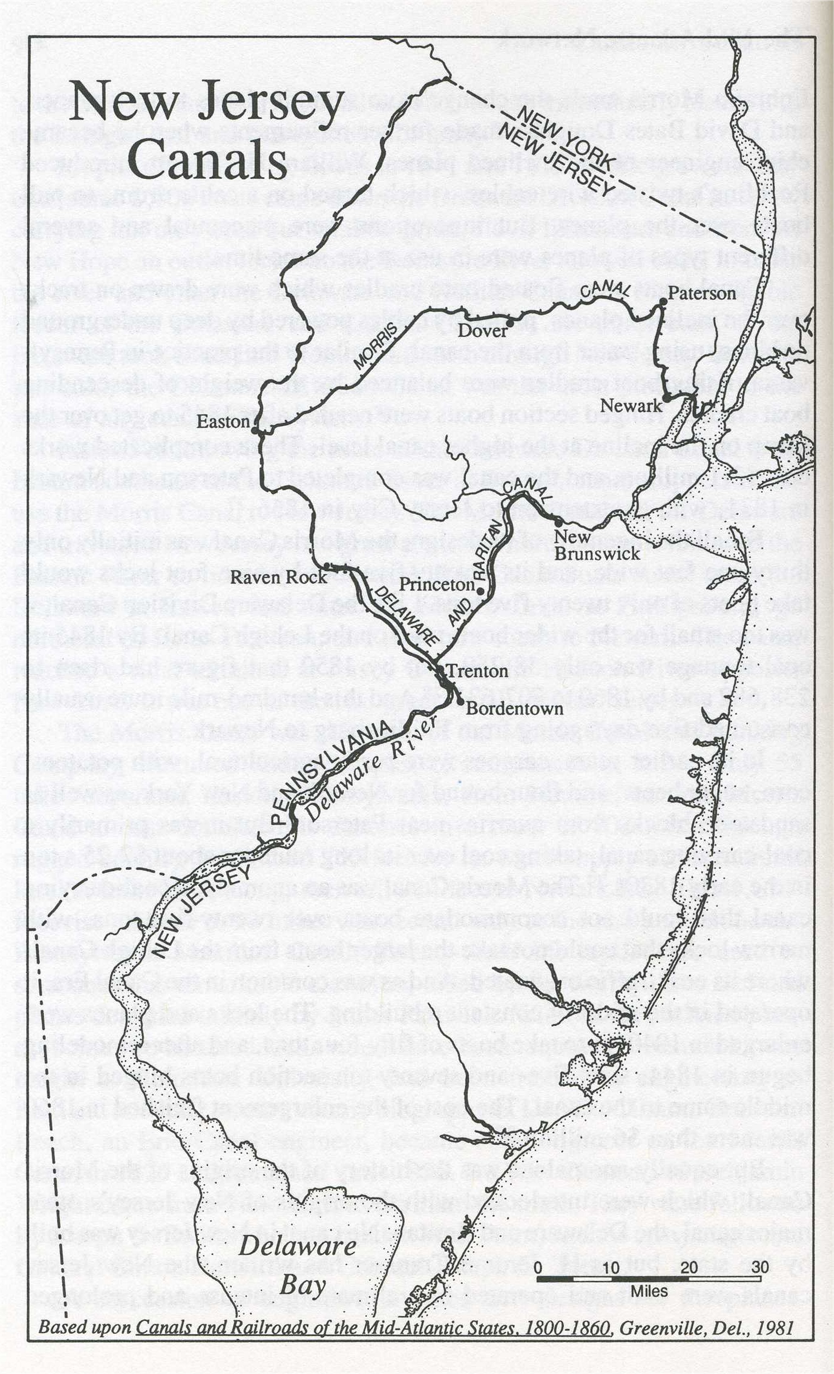
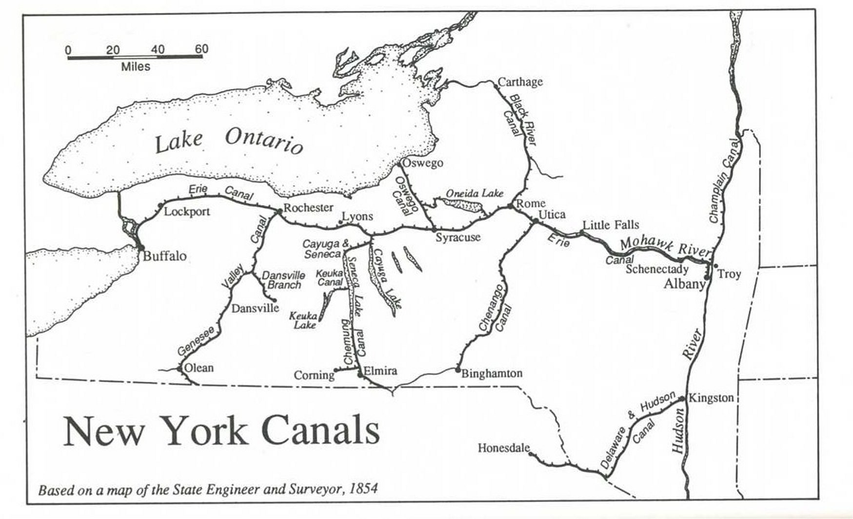