 |
 |
 |
 |
 |
|
|
|
|
|
![[image of flower]](../../ima/flowXS_04.gif)
Rideau Canal |
|
Note: This history provided by CCS
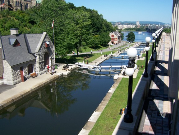
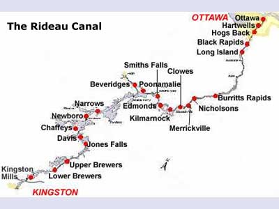
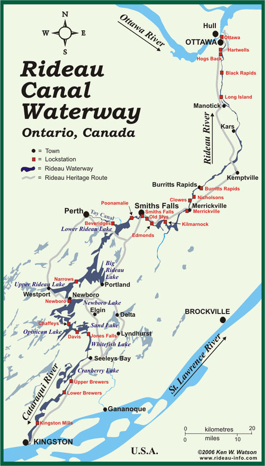
The Rideau Canal and (map), (map2) links the City of Kingston on Lake Ontario with the City of Ottawa on the Ottawa River. Opened in 1832, it is the oldest continuously operating canal in North America. Now a recreational waterway run by Parks Canada, most of the locks are still operated by hand, just as they were in 1832. Only 10% of this waterway consists of manmade canal cuts and locks, the rest follows a natural waterway of lakes and rivers. The Rideau Canal extends from the City of Kingston in the south to the City of Ottawa in the north, a distance of 202 km (125 miles). From Lake Ontario at Kingston the canal rises 50.6 metres (166.2 feet) to the summit of Upper Rideau Lake and then descends 83.8 metres (275 feet) to the Ottawa River at Ottawa. Built in 1826-1831, it uses 45 locks at 24 lockstations (see map) to allow vessels drafting up to 5 feet (1.5 m) to navigate the route. In the late 1880s two additional locks were built to connect the Town of Perth, via the Tay River, to the Rideau Canal. In 1926 the Rideau Canal was designated as a National Historic Site of Canada, in 2000 it was designated a Canadian Heritage River, and in 2005 it was nominated as a World Heritage Site. CCS The Rideau Project was conceived primarily for the defense of Canada, motivated by the war with the United States in 1812. In 1814, when it seemed the war might drag on for years, Sir George Prevost, commander of the military forces in Canada, directed Lt. Colonel George McDonnell (or Macdonnel) to improve the rapids and roads from Cornwall to Prescott and beyond and “to explore the Rideau communication.” There was a perceived need to provide a safe military vessel and supply route between Montreal and Kingston, out of range of American guns on the St. Lawrence River. Kingston, at that time, was Upper Canada’s main naval base and shipyard, but it was vulnerable if it couldn’t be kept safely supplied. The “Rideau communication” was already known from the 1783 survey of Lieutenant Gershom French, an officer in the Loyal Rangers (also known as “Jessup’s Corps”). McDonnell reported to Prevost that a batteau route could be established along the Rideau with the aid of several canal cuts, temporary locks, dams, and some portages. In 1815, General Drummond received instructions from London to obtain “estimates of expense of the Lachine Canal, and of the Ottawa and Rideau Rivers being made navigable.” So in April 1816, Drummond dispatched a young Lieutenant in the Royal Engineers, Joshua Jebb, to explore the route and prepare an estimate. At the time, two options were being considered. One, the present route of the Rideau Canal, and a second by way of Irish Creek (located between Merrickville and Kilmarnock), which would cut off the portion of the route through Smiths Falls and the northern and central Rideau lakes. Jebb preferred the Irish Creek route, as the “distance is much less, the interruptions by water not so frequent, and the route lies through a more fertile and much better line of country and numerous other advantages might be adduced.” In his plan for the Irish Creek route, Jebb said that “land carriage” would be required for about a five-mile stretch over the summit to the head of the Gananoque River. It would not have been a fully connected waterway. Jebb made his report in July 1816 to the new commander of the Royal Engineers in Canada, Lieutenant-Colonel Durnford. In February 1817, an advertisement was issued from the Lieutenant-Governor of Upper Canada’s office in York (Toronto) and published in several papers. It asked for tenders to render the whole or any part of a water communication between “La Chine” and Kingston by the course of the River Rideau, navigable for boats drafting up to three feet (0.9 m) of water and twelve feet (3.7 m) in width. The ad asked for tenders for both the Irish Creek route and for “opening the communication in the direction of the Rideau Lake, and the waters communicating from thence to Mud Lake [Newboro Lake], and from thence to Kingston.” The Lieutenant-Governor’s office was underwhelmed with the response: There was no interest in this project. Threats of war seemed to have ended and thoughts had turned strictly to commerce. For commerce purposes, the St. Lawrence River was much more attractive, and efforts were being made to render it more navigable. However, the Royal Engineers, concerned with matters of defence rather than commerce, continued to investigate various military routes, including the Rideau. George Ramsey, the 9th Earl of Dalhousie, became Governor of British North America in late 1820. His mentor, the Duke of Wellington, who defeated Napoleon at the Battle of Waterloo in 1815, and who later became the Prime Minister of England, was at that time head of the Board of Ordnance. Wellington was keen on the Rideau Route as a line of military communication and defense, and had been instrumental in establishing the settlements of Richmond and Perth, made up of retired military personnel. Dalhousie made a trip up the Ottawa River after the ice broke in 1821. In Richmond, he expounded on the importance of the Richmond Landing area (on the south side of the Ottawa River near the base of the Chaudičre Falls) as an essential debarkation point for settlers arriving in this area. He commanded the Superintendent of Settlers in Richmond to “take steps to affect the purchase, and to watch any advertisement of the sale of it, but to report to me before he concluded” [the purchase]. Captain LeBreton, a retired officer who had been present at the dinner where Dalhousie had stressed the importance of the Richmond Landing area, bought 400 acres of that area when it was offered at a public sale a few months later. He then offered to sell this land to Dalhousie at a price five to eight times greater than what he had paid. It was later said that this influenced Dalhousie on where not to place the head of the Rideau Canal. Dalhousie also asked his Lieutenant-Governor of Upper Canada, Sir Peregrine Maitland, to advise on ways the government might obtain parcels of land fronting the Ottawa River. In June 1823, Dalhousie arranged the purchase of 150 acres of land from Hugh Fraser, occupying what is now known as Entrance Valley, the head of the Rideau Canal. In 1821, the Provincial Legislature initiated a commission to look into the building of canal routes in Upper Canada. Captain John Macaulay of Kingston headed this commission. It was principally concerned with the St. Lawrence and Welland routes. Samuel Clowes, the commission’s civil engineer, later told Colonel By that the commissioners sometimes made him feel that for the Rideau he should simply be going through the motions. Samuel Clowes made a detailed survey of the Rideau Route and in his 1823 report to the Macaulay Commission he recommended the Rideau lakes route over the Irish Creek route, which had been recommended in 1816 by Lt. Jebb. One reason was the lack of sufficient reservoir water to maintain a canal system on the Irish Creek route. To get sufficient water, a ten mile feeder canal would have to be cut, at great expense, from Rideau Lake. Another reason was the discovery that the summit point on the Irish Creek route was actually 2.4 feet higher than Rideau Lake, not lower as previously assumed. Clowes made estimates for three sizes of canal systems. The first was for a canal with a 7 foot navigation depth. It was to have masonry locks 100 feet long by 22 feet wide. The second was for a canal with a 5 foot navigation depth. It was to have masonry locks 80 feet long by 15 feet wide. The third was for a canal with a 4 foot navigation depth. It was to have timber locks 75 feet long by 10 feet wide. His cost estimates ranged from Ł62,000 for the smallest lock size to Ł230,000 for the largest size. Clowes’ report was examined in London, and eventually tabled as part of the Macaulay Commission’s final report on “inland navigation” in the Upper Canada Legislature in April, 1825. The British Government offered the Provincial Legislature a loan of Ł70,000 to advance the Rideau project. The Legislature refused, citing prior commitments to the St. Lawrence route. Rebuffed, the British Government instructed an existing commission under the direction of General Sir James Carmichael Smyth, which was investigating Canada’s military defences, to investigate the Rideau Route and make recommendations. Smyth recommended that Clowes’ second estimate be adopted, with the modification that the locks be increased in size to 108 feet long by 20 feet wide with a depth of 5 feet. To compensate for the increase in lock size he added Ł500 per lock, increasing Clowes’ estimate of Ł145,000 to Ł169,000. It seems that Smyth knew that Clowes’ estimates had been low to encourage the project, but he didn’t want to ruffle too many provincial feathers, and mollified them by essentially adopting the provincial commissions’ (Clowes’) recommendations. The Rideau Project was placed under the control of the British Board of Ordnance, which was responsible for fortifications and canals. The Inspector-General of Fortifications was Gother Mann. It was likely Mann who recommended Lieutenant Colonel John By, a retired officer of the Royal Engineers, to take charge of the project. By had worked under Mann, in Canada, earlier in the century. By was retired on half pay in 1821 at the young age of 38. In March 1826 he was placed back on active duty and appointed Superintending Engineer of the Rideau Canal. Shortly after Lt. Colonel John By was appointed Superintending Engineer, he stated that the estimate given by Smyth was too low by a factor of four or five, based on the costs of building the Lachine Canal. Cost overruns, based on initial low construction cost estimates, would later become a major problem for By. In March 1826, Major General Sir James Carmichael Smyth wrote a memorandum to General Mann (Inspector-General of Fortifications) which read in part, “I am of the opinion that it will be found more economical and more expeditious to execute the greatest part, if not the whole, of the proposed Rideau Canal by contract …” This presumably had some influence on the fact that most of the Rideau Canal was eventually built by contractors, although the engineering was performed by officers of the Royal Engineers since By did not believe that civilian engineers were as reliable as those trained at the Royal Military Academy. By landed in Quebec on May 30, 1826. He headed up to Montreal a few days later and started preparations. In July 1826, he wrote to General Mann in England. In the letter he stressed the need to make the Rideau Route suitable for steamboat navigation, that such boats would become increasingly important from a military standpoint. This meant that the locks should be built to accommodate boats up to 130 feet in length and 50 feet in width. By fell sick in Montreal, as did his assistant Captain Daniel Bolton of the Royal Engineers, and it was not until September that By could travel up the Ottawa. During that time, John MacTaggart, who had been appointed by the Board of Ordnance in London to act as By’s Clerk of Works, arrived in Montreal. On September 7, 1826, the Commanding Royal Engineer in Canada, Colonel Durnford, received specific instructions from the Board of Ordnance in London for By to proceed with the building of the Rideau Canal. In mid-September 1826, By and a young Royal Engineer, Lieutenant Henry Pooley, together with several other assistants, including John MacTaggart, travelled to Wright’s Town (present-day Hull), arriving there on September 21. By and Pooley spent several days on a “minute inspection of the various bays” near the mouth of the Rideau River and “decided on the upper as best.” By’s choice was Sleigh Bay, later known as Entrance Bay. This also happened to be Dalhousie’s choice. The valley above Sleigh Bay was land he had purchased on behalf of the government from Hugh Fraser three years previously. On September 26, Dalhousie and Durnford arrived at Wright’s Town and went over the ground with By, approving of what he had done. Colonel By again proposed that consideration be given to larger locks, 150 feet long by 50 feet wide by 5 feet deep. Before he returned to Montreal in November, By initiated the building of a bridge across the Ottawa River to Wright’s Town (contracted to Thomas McKay) and the clearing of the trees in the Entrance Valley, and journeyed to Kingston to review the planned route of the canal with Samuel Clowes. Colonel By selected the final route for the canal in the fall of 1826. Tenders were placed in the papers in Canada and the U.S. in December 1826. By insisted that no contractor be given more work than he was capable of completing in a two year period. So the canal was divided into 23 sections, ranging in length from 1 ľ miles to 29 Ľ miles (3 km to 47 km), each with its own contractor. In January 1827 Colonel By made a quick tour of the route with several potential contractors. It was not until April 1827 that By made his first extensive survey tour of the Rideau Route. He completed designs for all the works at that time and made a new estimate of costs, Ł474,844. He sent his report to England in the care of Lt. Henry Pooley, who travelled to London to present By’s plans and estimates. Pooley also took with him By’s formal request for larger locks. By’s plans were reviewed by a board of senior officers, headed by Major General Alex Bryce. They were generally approved, with some minor modifications. His request for a larger lock size was sent to a committee for further study. Although some work had started in the fall of 1826, most of the contracts were awarded in 1827 and the main construction work started that year. The contractors hired their own workforces. Some of the contractors such as Philemon Wright and John Redpath already had available workers, Wright using his primarily French-Canadian timber camp workers and Redpath his Scottish and French-Canadian stone masons and labourers. Other contractors made use of readily available immigrant workers, mostly Irish, many of whom were flocking to the fledgling Bytown as word of this major government construction project spread. Colonel By requested four companies of Sappers and Miners, soldiers of the Royal Engineers, men experienced in excavations (saps are trenches) and construction. He was given two, the 7th and 15th companies, totalling 162 men. They initially settled into barracks built on the hill overlooking the Entrance Bay. Named Barrack Hill, it is known today as Parliament Hill. All the work was done by hand with the aid of a few draft animals. Men carried out most of the excavations with the use of shovels, pickaxes and wheelbarrows. Rock was laboriously hand drilled and blasted with merchant powder (a somewhat unstable mix of nitre, sulphur and charcoal) and black powder. Trees were cut down with felling axes. The large stones that made up the locks were set in place using simple hand cranes. Much of the skilled stone work was done by French Canadians who had experience on other lock projects and British/Scottish stonemasons. The unskilled labour was made up mostly of Irish immigrants and French Canadians. It is estimated that about 2,000 to 4,000 men per year worked to make the Rideau Canal a reality. These are very rough numbers since the numbers fluctuated month by month and no exact count is available. It is difficult to fully appreciate today the difficulties that were faced. Not only by the men working on the job, but in many cases by their families as well. Several of the Sappers and Miners had their families stationed with them. Some of the Irish labourers brought their families to the work sites, building rough shanty cabins. Others left their families in the newly created Bytown (Ottawa) or the more established town of Kingston. Colonel By’s reports, which listed the number of people working at each lockstation, also listed deaths, and these lists had columns for men, women and children. For instance, in 1830, during the “sickly season” which spanned from August to mid-September, in the southern Rideau (from Newboro to Kingston Mills), the area hardest hit by malaria, there were 1,327 men employed on the job of which 787 took sick with malaria. Deaths in that period were 27 men, 13 women and 15 children. About half of the overall deaths can be attributed to malaria. Malaria was prevalent in North America at that time (going back to at least the 1700s). The construction of the canal put hundreds of people in close proximity to each other, aiding in the transmission of the disease. It was not known at that time that mosquitoes transmitted the disease, it was thought to be the result of bad air (from which the name “malaria” is derived). Colonel By had large sections of trees cut down at each workstation to improve airflow, in order (he thought) to lessen the chances of malaria. The exact number of deaths is not known. It has been estimated that upwards of 1,000 men (no estimates available for women and children), may have died during the main construction period of 1827-1831. Extrapolations from the factual records that have survived indicate that about 500 men died of malaria alone. A rough guess is that perhaps another 500 died from other diseases (dysentery, small pox) and work related accidents (blasting accidents, rock falls, etc.). At the start of the first full construction season in 1827 the size of the locks was still an issue, and Colonel By was still lobbying hard for a larger lock size to accommodate steamboat navigation. A committee, headed by Lieutenant General Sir James Kempt, Lieutenant-Governor of Nova Scotia, was set up to review the size of the locks. The Kempt Committee toured the route with By in the spring of 1828, completing their report in Kingston by the end of June of that year. The Committee approved of locks 134 feet (40.8 m) long, by 33 feet (10.1 m) wide, with 5 feet (1.5 m) of water over the sills. They also approved the dismantling of existing masonry works in order to accommodate the larger size of lock. The revised estimate for the work was Ł576,757. John By’s actions were also approved by the commission, stating in their official report, “Economy has not been lost sight of by Colonel By and he had, in accordance with what he believed to be the spirit of his instructions, pushed forward the work and excited a degree of exertion through the whole Department which few individuals could have accomplished.” The canal construction was essentially completed by the fall of 1831. In December of that year the two companies of Sappers and Miners were disbanded in Bytown. Several of them were appointed as the first lockmasters. On May 24, 1832, Colonel By, his family and some fellow officers boarded the vessel Pumper, temporarily renamed Rideau, in Kingston for the grand opening voyage. It was on May 29, 1832, after stops at all the small communities along the way, when the Rideau/Pumper sailed into Bytown. The canal was officially open for navigation. Despite By’s economy, the final cost of the canal of Ł822,000 was far above the Kempt Committee’s estimate. A few months after the Rideau was opened to the public in 1832, By was recalled to London by the British Government to answer charges of financial mismanagement. A parliamentary committee was established and an inquiry was held. It should be remembered that this was a time of parliamentary reform in Britain. Parliament was not so much upset at the cost overrun as they were at the Board of Ordnance's defiance of parliamentary authority by authorizing By to complete the project regardless of the actual amount of the parliamentary grants. By was caught in the middle of a political battle. Once all the evidence was reviewed the parliamentary inquiry exonerated By of all wrongdoing. However, a victim of the politics of the day, By never received a formal commendation in recognition of the tremendous feat he had accomplished. John By died in 1836 at the age of 53, his achievements, the building of the Rideau Canal and the founding of Bytown (Ottawa), not publicly recognized. |
 |
|
|
|
|