|
Introduction
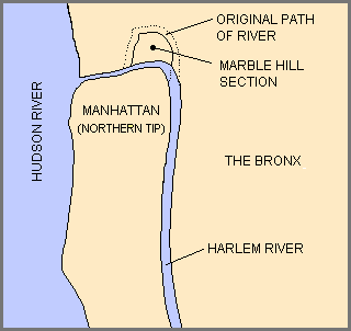
The Army Corps of Engineers constructed the Harlem River Ship Canal and
(map) in 1895, temporarily
making Marble Hill an island. After 1916, old Spuyten Duyvil Creek was filled in, making Marble Hill part of the
mainland, though it was separated by a railroad and a steep hill from the community of Spuyten Duyvil. Marble Hill
residents have successfully lobbied to politically remain in Manhattan ever since.
In the map are shown the canal, Spuyten Duyvil Creek, and the temporary island, Marble Hill, connected to the
mainland on the north by Kings Bridge. Tibbetts Creek is shown flowing south to the creek. Tibbetts still flowed
here until the 1920s, when it was relocated underground. Note the curved route the NY Central Railroad takes around
the creek. After Spuyten Duyvil Creek was filled in, the NYCentral was relocated along the Harlem and Hudson Rivers,
with the leftover track retained as a trainyard until the late 1960s.
Forgotten
|


![[image of flower]](../../ima/flowXS_04.gif)
